

純屬測試
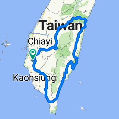
A cycling route starting in Xinying District, Taiwan, Taiwan.
Overview
About this route
D1 Fangliao
D2 Taitung Zhiben
D3 Ruifeng
D4 Hualien
D5 Wuling
D6 Linfengying
- -:--
- Duration
- 872.4 km
- Distance
- 6,685 m
- Ascent
- 6,686 m
- Descent
- ---
- Avg. speed
- ---
- Max. altitude

Continue with Bikemap
Use, edit, or download this cycling route
You would like to ride 純屬測試 or customize it for your own trip? Here is what you can do with this Bikemap route:
Free features
- Save this route as favorite or in collections
- Copy & plan your own version of this route
- Split it into stages to create a multi-day tour
- Sync your route with Garmin or Wahoo
Premium features
Free trial for 3 days, or one-time payment. More about Bikemap Premium.
- Navigate this route on iOS & Android
- Export a GPX / KML file of this route
- Create your custom printout (try it for free)
- Download this route for offline navigation
Discover more Premium features.
Get Bikemap PremiumFrom our community
Other popular routes starting in Xinying District
 小騎一段路
小騎一段路- Distance
- 6.8 km
- Ascent
- 233 m
- Descent
- 245 m
- Location
- Xinying District, Taiwan, Taiwan
 白河,六重溪
- Distance
- 45.3 km
- Ascent
- 219 m
- Descent
- 220 m
- Location
- Xinying District, Taiwan, Taiwan
 Day 4 鹽水 高雄市
- Distance
- 101.3 km
- Ascent
- 90 m
- Descent
- 91 m
- Location
- Xinying District, Taiwan, Taiwan
 純屬測試
純屬測試- Distance
- 872.4 km
- Ascent
- 6,685 m
- Descent
- 6,686 m
- Location
- Xinying District, Taiwan, Taiwan
 Xinying District - Xinying District
- Distance
- 0.8 km
- Ascent
- 0 m
- Descent
- 0 m
- Location
- Xinying District, Taiwan, Taiwan
 Xinying District - Xinying District
- Distance
- 9.9 km
- Ascent
- 12 m
- Descent
- 15 m
- Location
- Xinying District, Taiwan, Taiwan
 Tour 南嘉雲彰(實騎版) 110409
- Distance
- 93.1 km
- Ascent
- 44 m
- Descent
- 54 m
- Location
- Xinying District, Taiwan, Taiwan
 Tour 台南後壁 - 高雄 (實騎版)
- Distance
- 132.4 km
- Ascent
- 772 m
- Descent
- 789 m
- Location
- Xinying District, Taiwan, Taiwan
Open it in the app