

2018_Whisky_Moosbeeren_Schuxn
Whisky_Moosbeeren_Schuxn_Tag2
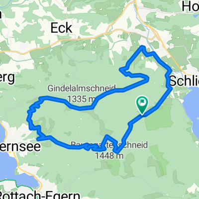
A cycling route starting in Schliersee, Bavaria, Germany.
Overview
About this route
- -:--
- Duration
- 51.4 km
- Distance
- 1,013 m
- Ascent
- 1,014 m
- Descent
- ---
- Avg. speed
- ---
- Max. altitude

Part of
2018_Whisky_Moosbeeren_Schuxn
4 stages
Route quality
Waytypes & surfaces along the route
Waytypes
Quiet road
23.1 km
(45 %)
Track
13.4 km
(26 %)
Surfaces
Paved
42.7 km
(83 %)
Unpaved
6.2 km
(12 %)
Asphalt
42.7 km
(83 %)
Gravel
4.1 km
(8 %)
Continue with Bikemap
Use, edit, or download this cycling route
You would like to ride Whisky_Moosbeeren_Schuxn_Tag2 or customize it for your own trip? Here is what you can do with this Bikemap route:
Free features
- Save this route as favorite or in collections
- Copy & plan your own version of this route
- Sync your route with Garmin or Wahoo
Premium features
Free trial for 3 days, or one-time payment. More about Bikemap Premium.
- Navigate this route on iOS & Android
- Export a GPX / KML file of this route
- Create your custom printout (try it for free)
- Download this route for offline navigation
Discover more Premium features.
Get Bikemap PremiumFrom our community
Other popular routes starting in Schliersee
 Valepprunde
- Distance
- 44.9 km
- Ascent
- 1,034 m
- Descent
- 1,031 m
- Location
- Schliersee, Bavaria, Germany
 Hexal Alpen-Triathlon Radstrecke
- Distance
- 39.4 km
- Ascent
- 734 m
- Descent
- 526 m
- Location
- Schliersee, Bavaria, Germany
 Schliersee über Valepp zum Tegernsee und zurück
- Distance
- 28.6 km
- Ascent
- 591 m
- Descent
- 641 m
- Location
- Schliersee, Bavaria, Germany
 Schliersee - Tegernsee
- Distance
- 23.2 km
- Ascent
- 925 m
- Descent
- 925 m
- Location
- Schliersee, Bavaria, Germany
 Gindelalm
- Distance
- 34.3 km
- Ascent
- 1,139 m
- Descent
- 1,139 m
- Location
- Schliersee, Bavaria, Germany
 Schliersee südliche Runde über Spitzingsee
- Distance
- 14.4 km
- Ascent
- 637 m
- Descent
- 634 m
- Location
- Schliersee, Bavaria, Germany
 Schliersee - Rohnberg - Neuhaus
- Distance
- 29.5 km
- Ascent
- 1,140 m
- Descent
- 1,144 m
- Location
- Schliersee, Bavaria, Germany
 Dreiseenrunde Schliersee-Tegernsee-Spitzingsee
- Distance
- 52.3 km
- Ascent
- 771 m
- Descent
- 765 m
- Location
- Schliersee, Bavaria, Germany
Open it in the app