

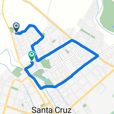
tranque millahue
A cycling route starting in Santa Cruz, O'Higgins Region, Chile.
Overview
About this route
- 2 h 9 min
- Duration
- 17.7 km
- Distance
- 692 m
- Ascent
- 686 m
- Descent
- 8.2 km/h
- Avg. speed
- ---
- Max. altitude

Route photos

Continue with Bikemap
Use, edit, or download this cycling route
You would like to ride tranque millahue or customize it for your own trip? Here is what you can do with this Bikemap route:
Free features
- Save this route as favorite or in collections
- Copy & plan your own version of this route
- Sync your route with Garmin or Wahoo
Premium features
Free trial for 3 days, or one-time payment. More about Bikemap Premium.
- Navigate this route on iOS & Android
- Export a GPX / KML file of this route
- Create your custom printout (try it for free)
- Download this route for offline navigation
Discover more Premium features.
Get Bikemap PremiumFrom our community
Other popular routes starting in Santa Cruz
 chepica
- Distance
- 30.1 km
- Ascent
- 88 m
- Descent
- 105 m
- Location
- Santa Cruz, O'Higgins Region, Chile
 tranque millahue
- Distance
- 17.7 km
- Ascent
- 692 m
- Descent
- 686 m
- Location
- Santa Cruz, O'Higgins Region, Chile
 DESAFIO EXTREMO LAS CORTADERAS CLONED FROM ROUTE 1261764
- Distance
- 84.9 km
- Ascent
- 1,615 m
- Descent
- 1,615 m
- Location
- Santa Cruz, O'Higgins Region, Chile
 ruta del vino colchagua
- Distance
- 45.4 km
- Ascent
- 132 m
- Descent
- 85 m
- Location
- Santa Cruz, O'Higgins Region, Chile
 SANTA CRUZ, CHEPICA Y NANCAGUA
- Distance
- 30.2 km
- Ascent
- 56 m
- Descent
- 13 m
- Location
- Santa Cruz, O'Higgins Region, Chile
 De Domeyko 116, Santa Cruz a 21 de Mayo 1467–1539, Santa Cruz
- Distance
- 23.8 km
- Ascent
- 43 m
- Descent
- 44 m
- Location
- Santa Cruz, O'Higgins Region, Chile
 De Luis Daza Osorio 886, Santa Cruz a Cabello 313, Santa Cruz
- Distance
- 3.6 km
- Ascent
- 6 m
- Descent
- 16 m
- Location
- Santa Cruz, O'Higgins Region, Chile
 Las cortaderas- Isla de Yaquil
- Distance
- 51.8 km
- Ascent
- 906 m
- Descent
- 905 m
- Location
- Santa Cruz, O'Higgins Region, Chile
Open it in the app