

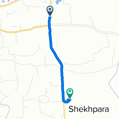
Bogra 1
A cycling route starting in Bogra, Rajshahi Division, Bangladesh.
Overview
About this route
- -:--
- Duration
- 17.3 km
- Distance
- 13 m
- Ascent
- 11 m
- Descent
- ---
- Avg. speed
- ---
- Max. altitude

Continue with Bikemap
Use, edit, or download this cycling route
You would like to ride Bogra 1 or customize it for your own trip? Here is what you can do with this Bikemap route:
Free features
- Save this route as favorite or in collections
- Copy & plan your own version of this route
- Sync your route with Garmin or Wahoo
Premium features
Free trial for 3 days, or one-time payment. More about Bikemap Premium.
- Navigate this route on iOS & Android
- Export a GPX / KML file of this route
- Create your custom printout (try it for free)
- Download this route for offline navigation
Discover more Premium features.
Get Bikemap PremiumFrom our community
Other popular routes starting in Bogra
 Matidali - Banani Eastern Bypass, Bogra to সাবগ্রাম
- Distance
- 2.4 km
- Ascent
- 0 m
- Descent
- 7 m
- Location
- Bogra, Rajshahi Division, Bangladesh
 Bogra 1
- Distance
- 17.3 km
- Ascent
- 13 m
- Descent
- 11 m
- Location
- Bogra, Rajshahi Division, Bangladesh
 Road 13, Bogra to R9V6+R98, Bogura
- Distance
- 3.5 km
- Ascent
- 41 m
- Descent
- 36 m
- Location
- Bogra, Rajshahi Division, Bangladesh
 V975+RHF, Bogura to R9V6+HCQ, Bogura
- Distance
- 3.9 km
- Ascent
- 25 m
- Descent
- 28 m
- Location
- Bogra, Rajshahi Division, Bangladesh
 বগুড়া to V935+733, Bogura
- Distance
- 2 km
- Ascent
- 23 m
- Descent
- 33 m
- Location
- Bogra, Rajshahi Division, Bangladesh
 Easy ride
- Distance
- 7.2 km
- Ascent
- 54 m
- Descent
- 57 m
- Location
- Bogra, Rajshahi Division, Bangladesh
 Bogra - Sariakandi Road to Bogra - Sariakandi Road
- Distance
- 0.3 km
- Ascent
- 7 m
- Descent
- 0 m
- Location
- Bogra, Rajshahi Division, Bangladesh
 R9W7+P8P, Bogura to Uposhohor Road 13, Bogra
- Distance
- 2.8 km
- Ascent
- 28 m
- Descent
- 28 m
- Location
- Bogra, Rajshahi Division, Bangladesh
Open it in the app