

20201115_おおたわら丘ポタ30 2020
A cycling route starting in Ōtawara, Tochigi, Japan.
Overview
About this route
大会公式MAP
- 2 h 3 min
- Duration
- 30.3 km
- Distance
- 302 m
- Ascent
- 304 m
- Descent
- 14.8 km/h
- Avg. speed
- ---
- Max. altitude

Route photos


Route quality
Waytypes & surfaces along the route
Waytypes
Road
13.4 km
(44 %)
Busy road
6.8 km
(23 %)
Surfaces
Paved
0.2 km
(<1 %)
Unpaved
0.1 km
(<1 %)
Paved (undefined)
0.2 km
(<1 %)
Gravel
0.1 km
(<1 %)
Undefined
30 km
(99 %)
Continue with Bikemap
Use, edit, or download this cycling route
You would like to ride 20201115_おおたわら丘ポタ30 2020 or customize it for your own trip? Here is what you can do with this Bikemap route:
Free features
- Save this route as favorite or in collections
- Copy & plan your own version of this route
- Sync your route with Garmin or Wahoo
Premium features
Free trial for 3 days, or one-time payment. More about Bikemap Premium.
- Navigate this route on iOS & Android
- Export a GPX / KML file of this route
- Create your custom printout (try it for free)
- Download this route for offline navigation
Discover more Premium features.
Get Bikemap PremiumFrom our community
Other popular routes starting in Ōtawara
 Nichien Momiji Line - Nikko 2days
- Distance
- 135.9 km
- Ascent
- 2,914 m
- Descent
- 2,853 m
- Location
- Ōtawara, Tochigi, Japan
 421-PC3-PC4
- Distance
- 52.7 km
- Ascent
- 344 m
- Descent
- 502 m
- Location
- Ōtawara, Tochigi, Japan
 day 8 part two
- Distance
- 4.4 km
- Ascent
- 24 m
- Descent
- 12 m
- Location
- Ōtawara, Tochigi, Japan
 20201115_おおたわら丘ポタ30 2020
- Distance
- 30.3 km
- Ascent
- 302 m
- Descent
- 304 m
- Location
- Ōtawara, Tochigi, Japan
 Day 7 Nasushiobara to Yabuki Station
- Distance
- 75.2 km
- Ascent
- 1,142 m
- Descent
- 1,097 m
- Location
- Ōtawara, Tochigi, Japan
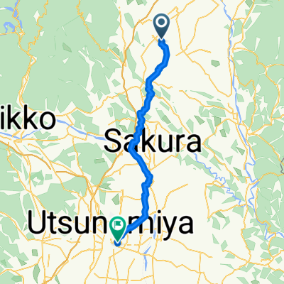 永田町, 那須塩原市へ川向町, 宇都宮市
- Distance
- 50.7 km
- Ascent
- 265 m
- Descent
- 386 m
- Location
- Ōtawara, Tochigi, Japan
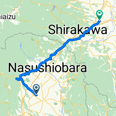
 Day 7 Nasushiobara to Shirakawa
- Distance
- 42.4 km
- Ascent
- 318 m
- Descent
- 197 m
- Location
- Ōtawara, Tochigi, Japan
 20231112_おおたわら 激ポタ60
- Distance
- 59.7 km
- Ascent
- 1,216 m
- Descent
- 1,215 m
- Location
- Ōtawara, Tochigi, Japan
Open it in the app