

un grand tour
A cycling route starting in Saint-Sauveur, Quebec, Canada.
Overview
About this route
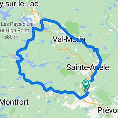
a grand tour, half on busy roads, half in the countryside. This route requires resources to finish.
- -:--
- Duration
- 96.9 km
- Distance
- 937 m
- Ascent
- 994 m
- Descent
- ---
- Avg. speed
- 365 m
- Max. altitude

Route quality
Waytypes & surfaces along the route
Waytypes
Road
46.5 km
(48 %)
Quiet road
9.7 km
(10 %)
Surfaces
Paved
91.1 km
(94 %)
Unpaved
1.9 km
(2 %)
Asphalt
66.8 km
(69 %)
Paved (undefined)
24.2 km
(25 %)
Continue with Bikemap
Use, edit, or download this cycling route
You would like to ride un grand tour or customize it for your own trip? Here is what you can do with this Bikemap route:
Free features
- Save this route as favorite or in collections
- Copy & plan your own version of this route
- Split it into stages to create a multi-day tour
- Sync your route with Garmin or Wahoo
Premium features
Free trial for 3 days, or one-time payment. More about Bikemap Premium.
- Navigate this route on iOS & Android
- Export a GPX / KML file of this route
- Create your custom printout (try it for free)
- Download this route for offline navigation
Discover more Premium features.
Get Bikemap PremiumFrom our community
Other popular routes starting in Saint-Sauveur
 Journée GIRO 2014 - 46km
- Distance
- 46.4 km
- Ascent
- 398 m
- Descent
- 397 m
- Location
- Saint-Sauveur, Quebec, Canada
 boucle st-sau, lachute, ste anne des lacs
- Distance
- 105.3 km
- Ascent
- 575 m
- Descent
- 575 m
- Location
- Saint-Sauveur, Quebec, Canada
 62 km
62 km- Distance
- 62.9 km
- Ascent
- 436 m
- Descent
- 434 m
- Location
- Saint-Sauveur, Quebec, Canada
 Boucle 28 Km Ste Adele
- Distance
- 27.8 km
- Ascent
- 411 m
- Descent
- 412 m
- Location
- Saint-Sauveur, Quebec, Canada
 Boucle Morin-Heights - Milles-Iles
- Distance
- 32.2 km
- Ascent
- 398 m
- Descent
- 396 m
- Location
- Saint-Sauveur, Quebec, Canada
 Morin-heights-st-adolphe-ste-agathe-val-david-piedmont-st-sauveur-morin-heights
- Distance
- 67.1 km
- Ascent
- 643 m
- Descent
- 647 m
- Location
- Saint-Sauveur, Quebec, Canada
 Tour du lac Connely
- Distance
- 45.9 km
- Ascent
- 397 m
- Descent
- 399 m
- Location
- Saint-Sauveur, Quebec, Canada
 ssv-st adolphe-ste agathe-ste adele-ssv
- Distance
- 70.6 km
- Ascent
- 913 m
- Descent
- 1,010 m
- Location
- Saint-Sauveur, Quebec, Canada
Open it in the app