Dráva túra - 3.nap
- 100.4 km
- 1,672 m
- 531 m
- Oberdrauburg, Carinthia, Austria
A cycling route starting in Oberdrauburg, Carinthia, Austria.
Overview
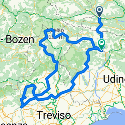
There and back on a quality road 76 km and 1863 meters of elevation, the start and end of the journey is at the parking lot at road no. 110 above the town of Waidach in Oberdrauburg, it is necessary to have with you at least a rear light (red blinking light) also suitable is a front one, two tunnels are passed through there and back (4 x tunnel). From the parking lot at an altitude of 715 m right uphill on road no. 110 through Kotschach-Mauthen on Plockenpass Street up to the state border with Italy, which is at the highest point of the route at 1355 m at passo di Monte Croce Carnico, a necessary initiation, a chance for refreshments (everywhere they sell quite nice postcards, but there is no mailbox; a helpful saleswoman took a postcard and mailed it). There are military fortifications and memorials of the battles of World War I. From the pass we descend into Italy, along wonderful serpentine roads with beautiful views of the countryside. While descending on Via Nazionale road no. 52bis we notice a noticeable change in climate, dry air and great heat, the temperature has risen significantly. We pass through the lovely town of Timau and continue for a while on the road until the end of the municipality of Muse, where we turn around and head back to the town of Timau, where in a side street we stop at a nice restaurant with a small outdoor seating area in pleasant shade, we have lunch, what else but spaghetti, they were excellent, an outstanding salad (about 6 little bottles with ingredients), good beer. Upon leaving the town before the climb to the pass in the sweltering heat, we treat ourselves to ice cream. During the ascent with beautiful and interesting serpentine (2 x 4 floors of road directly above each other) there are fortunately shady places; after climbing above 1100 m the air is again pleasant and humid. We cross back into Austria via passo di M.Croce and return the same way to the starting point of the journey at the parking lot above Waidach.
created this 15 years ago
Continue with Bikemap
You would like to ride Alpy - z Rakouska na oběd do Itálie or customize it for your own trip? Here is what you can do with this Bikemap route:
Free trial for 3 days, or one-time payment. More about Bikemap Premium.
Discover more Premium features.
Get Bikemap PremiumFrom our community
Open it in the app