

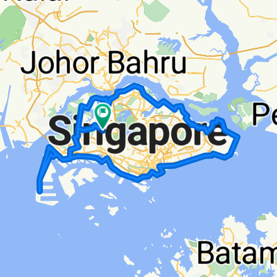
North - East "Coastline" Tour
A cycling route starting in Singapore, Central Singapore Community Development Council, Singapore.
Overview
About this route
45 km one way bike tour
Woodlands Checkpoint to Changi Point Ferry Terminal
4 pit stops: (1)PassionWave@Sembawang, (2)Waterway Point/Punggol Settlement, (3)Coney Island, (4)Changi Village
- -:--
- Duration
- 45.3 km
- Distance
- 149 m
- Ascent
- 165 m
- Descent
- ---
- Avg. speed
- ---
- Max. altitude

Route quality
Waytypes & surfaces along the route
Waytypes
Cycleway
17.7 km
(39 %)
Pedestrian area
4.5 km
(10 %)
Surfaces
Paved
34 km
(75 %)
Unpaved
4.1 km
(9 %)
Asphalt
31.2 km
(69 %)
Gravel
3.6 km
(8 %)
Continue with Bikemap
Use, edit, or download this cycling route
You would like to ride North - East "Coastline" Tour or customize it for your own trip? Here is what you can do with this Bikemap route:
Free features
- Save this route as favorite or in collections
- Copy & plan your own version of this route
- Sync your route with Garmin or Wahoo
Premium features
Free trial for 3 days, or one-time payment. More about Bikemap Premium.
- Navigate this route on iOS & Android
- Export a GPX / KML file of this route
- Create your custom printout (try it for free)
- Download this route for offline navigation
Discover more Premium features.
Get Bikemap PremiumFrom our community
Other popular routes starting in Singapore
 RTI CHILL RIDE
- Distance
- 173.2 km
- Ascent
- 191 m
- Descent
- 197 m
- Location
- Singapore, Central Singapore Community Development Council, Singapore
 NorthernScenicExplorer
- Distance
- 38.8 km
- Ascent
- 177 m
- Descent
- 177 m
- Location
- Singapore, Central Singapore Community Development Council, Singapore
 Tampines Simei Loop
- Distance
- 14.2 km
- Ascent
- 94 m
- Descent
- 91 m
- Location
- Singapore, Central Singapore Community Development Council, Singapore
 RTI Shore Loop
- Distance
- 132 km
- Ascent
- 635 m
- Descent
- 642 m
- Location
- Singapore, Central Singapore Community Development Council, Singapore
 Give it a hundred %
- Distance
- 99.7 km
- Ascent
- 95 m
- Descent
- 87 m
- Location
- Singapore, Central Singapore Community Development Council, Singapore
 First Round Island for 2021
- Distance
- 122.5 km
- Ascent
- 1,707 m
- Descent
- 1,705 m
- Location
- Singapore, Central Singapore Community Development Council, Singapore
 Tampines To Hyderabad/Kay Siang/Ridley Park
- Distance
- 58.1 km
- Ascent
- 477 m
- Descent
- 477 m
- Location
- Singapore, Central Singapore Community Development Council, Singapore
 Coast 2 Coast Loop (PCN)
- Distance
- 98.3 km
- Ascent
- 1,007 m
- Descent
- 1,007 m
- Location
- Singapore, Central Singapore Community Development Council, Singapore
Open it in the app