

Rund um das NFH
A cycling route starting in Herzogenrath, North Rhine-Westphalia, Germany.
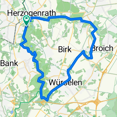
Overview
About this route
Around the NFH: we hike through the Floeßer Bush, the Herbacher Forest in the Übach Valley, walk along a tree education trail, and finally, after a hill, through fields and meadows. Here, there is a good panoramic view with several coal heaps. We cross the Dynamitwäldchen and meet the Floeßer Bush again. A new path leads us to the parking lot.
- -:--
- Duration
- 7.8 km
- Distance
- 61 m
- Ascent
- 59 m
- Descent
- ---
- Avg. speed
- ---
- Max. altitude

Continue with Bikemap
Use, edit, or download this cycling route
You would like to ride Rund um das NFH or customize it for your own trip? Here is what you can do with this Bikemap route:
Free features
- Save this route as favorite or in collections
- Copy & plan your own version of this route
- Sync your route with Garmin or Wahoo
Premium features
Free trial for 3 days, or one-time payment. More about Bikemap Premium.
- Navigate this route on iOS & Android
- Export a GPX / KML file of this route
- Create your custom printout (try it for free)
- Download this route for offline navigation
Discover more Premium features.
Get Bikemap PremiumFrom our community
Other popular routes starting in Herzogenrath
 Testrunde Wurmtal
- Distance
- 22.8 km
- Ascent
- 689 m
- Descent
- 684 m
- Location
- Herzogenrath, North Rhine-Westphalia, Germany
 AZAN Tour 2 An Wurm Und Broichbach
- Distance
- 29.4 km
- Ascent
- 146 m
- Descent
- 146 m
- Location
- Herzogenrath, North Rhine-Westphalia, Germany
 Tolle Landschaftsroute
- Distance
- 25.5 km
- Ascent
- 205 m
- Descent
- 222 m
- Location
- Herzogenrath, North Rhine-Westphalia, Germany
 Tolle Landschaftsroute CLONED FROM ROUTE 220895
- Distance
- 25.5 km
- Ascent
- 162 m
- Descent
- 162 m
- Location
- Herzogenrath, North Rhine-Westphalia, Germany
 rund um Kohlscheid
- Distance
- 36.9 km
- Ascent
- 192 m
- Descent
- 173 m
- Location
- Herzogenrath, North Rhine-Westphalia, Germany
 Merkstein-Landgraaf-Teverner Heide-Merkstein
- Distance
- 32.4 km
- Ascent
- 189 m
- Descent
- 189 m
- Location
- Herzogenrath, North Rhine-Westphalia, Germany
 West-Bike-Tagestour
- Distance
- 74.9 km
- Ascent
- 448 m
- Descent
- 445 m
- Location
- Herzogenrath, North Rhine-Westphalia, Germany
 An Wurm und Broichbach
- Distance
- 28.4 km
- Ascent
- 133 m
- Descent
- 111 m
- Location
- Herzogenrath, North Rhine-Westphalia, Germany
Open it in the app