
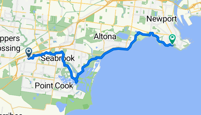
Skeleton Creek - Williamstown
A cycling route starting in Hoppers Crossing, Victoria, Australia.
Overview
About this route
- -:--
- Duration
- 23.3 km
- Distance
- 12 m
- Ascent
- 12 m
- Descent
- ---
- Avg. speed
- ---
- Max. altitude

Route quality
Waytypes & surfaces along the route
Waytypes
Cycleway
21.2 km
(91 %)
Road
0.9 km
(4 %)
Surfaces
Paved
22.8 km
(98 %)
Concrete
18.1 km
(77 %)
Paved (undefined)
2.9 km
(12 %)
Continue with Bikemap
Use, edit, or download this cycling route
You would like to ride Skeleton Creek - Williamstown or customize it for your own trip? Here is what you can do with this Bikemap route:
Free features
- Save this route as favorite or in collections
- Copy & plan your own version of this route
- Sync your route with Garmin or Wahoo
Premium features
Free trial for 3 days, or one-time payment. More about Bikemap Premium.
- Navigate this route on iOS & Android
- Export a GPX / KML file of this route
- Create your custom printout (try it for free)
- Download this route for offline navigation
Discover more Premium features.
Get Bikemap PremiumFrom our community
Other popular routes starting in Hoppers Crossing
 Sanctuary Lakes Loop ++
- Distance
- 24.4 km
- Ascent
- 35 m
- Descent
- 35 m
- Location
- Hoppers Crossing, Victoria, Australia
 Werribee Melbourne Loop
- Distance
- 107.1 km
- Ascent
- 132 m
- Descent
- 153 m
- Location
- Hoppers Crossing, Victoria, Australia
 H to H
- Distance
- 12.2 km
- Ascent
- 32 m
- Descent
- 16 m
- Location
- Hoppers Crossing, Victoria, Australia
 2 West Cornhill Way, Point Cook to Dunnings Road, Point Cook
- Distance
- 0.3 km
- Ascent
- 0 m
- Descent
- 0 m
- Location
- Hoppers Crossing, Victoria, Australia
 Fairbridge Road 67, Point Cook to Fairbridge Road 63, Point Cook
- Distance
- 52 km
- Ascent
- 167 m
- Descent
- 169 m
- Location
- Hoppers Crossing, Victoria, Australia
 2 Greenbank Way, Point Cook to 6 Burnley Street, Point Cook
- Distance
- 4.3 km
- Ascent
- 10 m
- Descent
- 7 m
- Location
- Hoppers Crossing, Victoria, Australia
 Fed Trail to Altona
- Distance
- 37.8 km
- Ascent
- 278 m
- Descent
- 279 m
- Location
- Hoppers Crossing, Victoria, Australia
 179 Princes Highway, Werribee to 39 Chirnside Ave, Werribee
- Distance
- 3.4 km
- Ascent
- 3 m
- Descent
- 3 m
- Location
- Hoppers Crossing, Victoria, Australia
Open it in the app