
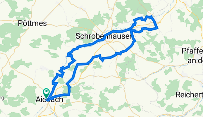
Altbayerischer Oxenweg
A cycling route starting in Aichach, Bavaria, Germany.
Overview
About this route
Über vier Jahrhunderte lang wurden vom Spätmittelalter bis in die Frühe Neuzeit hinein jährlich bis zu 200.000 Grauochsen aus der ungarischen Tiefebene und aus Transsylvanien in den Westen exportiert. Eines der Hauptziele des Projekts „Altbaierischer Oxenweg“ im „Schrobenhausener und Wittelsbacher Land" ist die Entwicklung von Wander- und Radwegen. (Tourbeschreibung unter: thod_er@gmx.de)
- -:--
- Duration
- 68.6 km
- Distance
- 10,680 m
- Ascent
- 11,123 m
- Descent
- ---
- Avg. speed
- 538 m
- Avg. speed
Route quality
Waytypes & surfaces along the route
Waytypes
Quiet road
40.7 km
(59 %)
Path
9.3 km
(14 %)
Surfaces
Paved
42.4 km
(62 %)
Unpaved
8.8 km
(13 %)
Asphalt
38.7 km
(56 %)
Gravel
6.3 km
(9 %)
Continue with Bikemap
Use, edit, or download this cycling route
You would like to ride Altbayerischer Oxenweg or customize it for your own trip? Here is what you can do with this Bikemap route:
Free features
- Save this route as favorite or in collections
- Copy & plan your own version of this route
- Sync your route with Garmin or Wahoo
Premium features
Free trial for 3 days, or one-time payment. More about Bikemap Premium.
- Navigate this route on iOS & Android
- Export a GPX / KML file of this route
- Create your custom printout (try it for free)
- Download this route for offline navigation
Discover more Premium features.
Get Bikemap PremiumFrom our community
Other popular routes starting in Aichach
 Aichach 5
- Distance
- 38.2 km
- Ascent
- 113 m
- Descent
- 112 m
- Location
- Aichach, Bavaria, Germany
 Ultimate Bike Challenge
- Distance
- 23 km
- Ascent
- 183 m
- Descent
- 138 m
- Location
- Aichach, Bavaria, Germany
 und um Aichach
- Distance
- 39.1 km
- Ascent
- 323 m
- Descent
- 323 m
- Location
- Aichach, Bavaria, Germany
 Aichach-Sielenbach-Thalhausen-Schiltberg-Kühbach--Obermauerbach-Aichach
- Distance
- 51.6 km
- Ascent
- 280 m
- Descent
- 278 m
- Location
- Aichach, Bavaria, Germany
 Algertshauser Ammerseerunde
- Distance
- 126.1 km
- Ascent
- 845 m
- Descent
- 819 m
- Location
- Aichach, Bavaria, Germany
 hügelig durch Wald und Flur
- Distance
- 31.5 km
- Ascent
- 250 m
- Descent
- 249 m
- Location
- Aichach, Bavaria, Germany
 aichach
- Distance
- 12.5 km
- Ascent
- 78 m
- Descent
- 44 m
- Location
- Aichach, Bavaria, Germany
 Aichach-Aindling
- Distance
- 61.6 km
- Ascent
- 515 m
- Descent
- 515 m
- Location
- Aichach, Bavaria, Germany
Open it in the app