
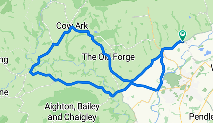
barn cowark Walker fold 17
A cycling route starting in Clitheroe, England, United Kingdom.
Overview
About this route
- 1 h 42 min
- Duration
- 27.6 km
- Distance
- 327 m
- Ascent
- 325 m
- Descent
- 16.2 km/h
- Avg. speed
- ---
- Max. altitude

Route quality
Waytypes & surfaces along the route
Waytypes
Road
27.4 km
(99 %)
Undefined
0.3 km
(1 %)
Surfaces
Paved
3.3 km
(12 %)
Asphalt
3.3 km
(12 %)
Undefined
24.3 km
(88 %)
Continue with Bikemap
Use, edit, or download this cycling route
You would like to ride barn cowark Walker fold 17 or customize it for your own trip? Here is what you can do with this Bikemap route:
Free features
- Save this route as favorite or in collections
- Copy & plan your own version of this route
- Sync your route with Garmin or Wahoo
Premium features
Free trial for 3 days, or one-time payment. More about Bikemap Premium.
- Navigate this route on iOS & Android
- Export a GPX / KML file of this route
- Create your custom printout (try it for free)
- Download this route for offline navigation
Discover more Premium features.
Get Bikemap PremiumFrom our community
Other popular routes starting in Clitheroe
 barn cowark Walker fold 17
- Distance
- 27.6 km
- Ascent
- 327 m
- Descent
- 325 m
- Location
- Clitheroe, England, United Kingdom
 Ribble Valley Villages
- Distance
- 46.8 km
- Ascent
- 366 m
- Descent
- 362 m
- Location
- Clitheroe, England, United Kingdom
 Clitheroe-8-Waddy
- Distance
- 12.8 km
- Ascent
- 54 m
- Descent
- 42 m
- Location
- Clitheroe, England, United Kingdom
 Downham Circular
- Distance
- 29.1 km
- Ascent
- 616 m
- Descent
- 614 m
- Location
- Clitheroe, England, United Kingdom
 Tractor Run 2020
- Distance
- 47.3 km
- Ascent
- 447 m
- Descent
- 447 m
- Location
- Clitheroe, England, United Kingdom
 Clitheroe Circular
- Distance
- 29.8 km
- Ascent
- 448 m
- Descent
- 444 m
- Location
- Clitheroe, England, United Kingdom
 LEJOG Day 8a - Slaidburn to Carlisle
- Distance
- 121.8 km
- Ascent
- 841 m
- Descent
- 973 m
- Location
- Clitheroe, England, United Kingdom
 2nd-route
- Distance
- 10 km
- Ascent
- 90 m
- Descent
- 66 m
- Location
- Clitheroe, England, United Kingdom
Open it in the app