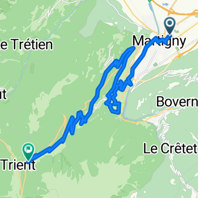
Z Martigny k Ženevskému jezeru do Vevey
A cycling route starting in Martigny-Ville, Valais, Switzerland.
Overview
About this route
Rovinatá trasa podél Rhony.
- -:--
- Duration
- 59 km
- Distance
- 93 m
- Ascent
- 186 m
- Descent
- ---
- Avg. speed
- ---
- Avg. speed
Route quality
Waytypes & surfaces along the route
Waytypes
Access road
15.5 km
(26 %)
Busy road
13.8 km
(23 %)
Surfaces
Paved
49.8 km
(84 %)
Unpaved
1.1 km
(2 %)
Asphalt
48.2 km
(82 %)
Paved (undefined)
1.1 km
(2 %)
Route highlights
Points of interest along the route
Photo after 2.4 km
výhled s věže hradu
Photo after 2.8 km
Martigny
Photo after 2.9 km
hrad Batiaz
Photo after 17.2 km
Saint Maurice
Photo after 26.8 km
podél Rhony
Photo after 46.4 km
hrad Chillon
Photo after 47.9 km
hrad Chillon
Photo after 48 km
hrad Chillon
Photo after 49 km
hrad Chillon
Photo after 58.7 km
Ženevské jezero z Vevey
Continue with Bikemap
Use, edit, or download this cycling route
You would like to ride Z Martigny k Ženevskému jezeru do Vevey or customize it for your own trip? Here is what you can do with this Bikemap route:
Free features
- Save this route as favorite or in collections
- Copy & plan your own version of this route
- Sync your route with Garmin or Wahoo
Premium features
Free trial for 3 days, or one-time payment. More about Bikemap Premium.
- Navigate this route on iOS & Android
- Export a GPX / KML file of this route
- Create your custom printout (try it for free)
- Download this route for offline navigation
Discover more Premium features.
Get Bikemap PremiumFrom our community
Other popular routes starting in Martigny-Ville
- [Martigny_000] Col de la Croix de Cœur.
- Distance
- 69.2 km
- Ascent
- 1,694 m
- Descent
- 1,695 m
- Location
- Martigny-Ville, Valais, Switzerland
- VR04 Martigny-St Gingolph.kml - VR04 Martigny-St Gingolph.kml_VR04 Martigny-St Gingolph
- Distance
- 60.4 km
- Ascent
- 408 m
- Descent
- 484 m
- Location
- Martigny-Ville, Valais, Switzerland
- Martigny nach Oberwald
- Distance
- 138.3 km
- Ascent
- 2,322 m
- Descent
- 1,411 m
- Location
- Martigny-Ville, Valais, Switzerland
- Forclaz backroad - Champex Lac - Col des Planches / Col du Lein
- Distance
- 102 km
- Ascent
- 3,119 m
- Descent
- 3,118 m
- Location
- Martigny-Ville, Valais, Switzerland
- Martigny-Thollon
- Distance
- 69.9 km
- Ascent
- 1,891 m
- Descent
- 1,444 m
- Location
- Martigny-Ville, Valais, Switzerland
- Alpencross 2007/1 - Martigny/CH bis Aosta/I
- Distance
- 89.2 km
- Ascent
- 2,705 m
- Descent
- 2,584 m
- Location
- Martigny-Ville, Valais, Switzerland
- Colonel
- Distance
- 214.5 km
- Ascent
- 3,599 m
- Descent
- 3,601 m
- Location
- Martigny-Ville, Valais, Switzerland
- 1. Etappe: Martigny - Rund um den Mont Blanc nach Les Saisies
- Distance
- 100 km
- Ascent
- 2,702 m
- Descent
- 1,515 m
- Location
- Martigny-Ville, Valais, Switzerland
Open it in the app