

Alpen Ende
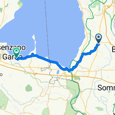
A cycling route starting in Colà, Veneto, Italy.
Overview
About this route
- -:--
- Duration
- 29.1 km
- Distance
- 149 m
- Ascent
- 200 m
- Descent
- ---
- Avg. speed
- ---
- Max. altitude

Route quality
Waytypes & surfaces along the route
Waytypes
Road
15.4 km
(53 %)
Cycleway
7.9 km
(27 %)
Surfaces
Paved
28.2 km
(97 %)
Unpaved
0.6 km
(2 %)
Asphalt
28.2 km
(97 %)
Gravel
0.6 km
(2 %)
Undefined
0.3 km
(1 %)
Continue with Bikemap
Use, edit, or download this cycling route
You would like to ride Alpen Ende or customize it for your own trip? Here is what you can do with this Bikemap route:
Free features
- Save this route as favorite or in collections
- Copy & plan your own version of this route
- Sync your route with Garmin or Wahoo
Premium features
Free trial for 3 days, or one-time payment. More about Bikemap Premium.
- Navigate this route on iOS & Android
- Export a GPX / KML file of this route
- Create your custom printout (try it for free)
- Download this route for offline navigation
Discover more Premium features.
Get Bikemap PremiumFrom our community
Other popular routes starting in Colà
 Colá di Lazise - San Benedetto Po
- Distance
- 76.1 km
- Ascent
- 152 m
- Descent
- 255 m
- Location
- Colà, Veneto, Italy
 Lazise a Via Dante, Lazise
- Distance
- 21.7 km
- Ascent
- 106 m
- Descent
- 110 m
- Location
- Colà, Veneto, Italy
 Südrunde Gardasee
- Distance
- 72.7 km
- Ascent
- 443 m
- Descent
- 443 m
- Location
- Colà, Veneto, Italy
 Von Lazise bis Sirmione
- Distance
- 22.3 km
- Ascent
- 90 m
- Descent
- 134 m
- Location
- Colà, Veneto, Italy
 Garda_tour_m_baldo
- Distance
- 116.6 km
- Ascent
- 2,501 m
- Descent
- 2,471 m
- Location
- Colà, Veneto, Italy
 Peschiera - Garda - Peschiera
- Distance
- 37.5 km
- Ascent
- 324 m
- Descent
- 323 m
- Location
- Colà, Veneto, Italy
 Runde
Runde- Distance
- 28.5 km
- Ascent
- 261 m
- Descent
- 260 m
- Location
- Colà, Veneto, Italy
 Aufnahme vom 14.05.2016, 17:31
- Distance
- 6.5 km
- Ascent
- 46 m
- Descent
- 45 m
- Location
- Colà, Veneto, Italy
Open it in the app