

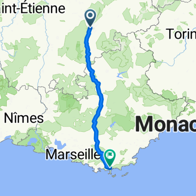
10-M. Grenoble - Saint-Étienne (156,5 Km)
A cycling route starting in Grenoble, Auvergne-Rhône-Alpes, France.
Overview
About this route
- -:--
- Duration
- 156.5 km
- Distance
- 1,148 m
- Ascent
- 806 m
- Descent
- ---
- Avg. speed
- 680 m
- Max. altitude
Route quality
Waytypes & surfaces along the route
Waytypes
Road
42.2 km
(27 %)
Quiet road
31.3 km
(20 %)
Surfaces
Paved
92.3 km
(59 %)
Unpaved
1.6 km
(1 %)
Asphalt
92.3 km
(59 %)
Ground
1.6 km
(1 %)
Undefined
62.6 km
(40 %)
Route highlights
Points of interest along the route
Point of interest after 29.6 km
Cote de BEAUCROISSANT (3) Km. 65,9 Altitude: 433 m 25,3 Km at 6,2%
Point of interest after 103.9 km
LOTISSEMENT BEAU SOLEIL Sprint (Km 103)
Point of interest after 123.6 km
Col de PAVEZIN · No point ·
Point of interest after 128 km
Le CROIX de MONTVIEUX (1ª) Km. 127,7 Altitude: 810 m XX,X Km at X,X%
Point of interest after 156.4 km
CRÊT de ROC (3) Km. 156,5 Altitude: 557 m XX,XX Km at XX,XX%
Continue with Bikemap
Use, edit, or download this cycling route
You would like to ride 10-M. Grenoble - Saint-Étienne (156,5 Km) or customize it for your own trip? Here is what you can do with this Bikemap route:
Free features
- Save this route as favorite or in collections
- Copy & plan your own version of this route
- Split it into stages to create a multi-day tour
- Sync your route with Garmin or Wahoo
Premium features
Free trial for 3 days, or one-time payment. More about Bikemap Premium.
- Navigate this route on iOS & Android
- Export a GPX / KML file of this route
- Create your custom printout (try it for free)
- Download this route for offline navigation
Discover more Premium features.
Get Bikemap PremiumFrom our community
Other popular routes starting in Grenoble
 Chartreuse - Col de Porte et col du Coq
- Distance
- 70.2 km
- Ascent
- 1,813 m
- Descent
- 1,814 m
- Location
- Grenoble, Auvergne-Rhône-Alpes, France
 Day 3 - Grenoble to Saint-Pierre-d'Argençon
- Distance
- 99.6 km
- Ascent
- 1,451 m
- Descent
- 883 m
- Location
- Grenoble, Auvergne-Rhône-Alpes, France
 alpes 2018
- Distance
- 303.2 km
- Ascent
- 2,053 m
- Descent
- 2,232 m
- Location
- Grenoble, Auvergne-Rhône-Alpes, France
 CRI Grenoble-Grenoble (Tour 2011)
- Distance
- 42.5 km
- Ascent
- 616 m
- Descent
- 620 m
- Location
- Grenoble, Auvergne-Rhône-Alpes, France
 Lac De Laffrey
- Distance
- 79.4 km
- Ascent
- 1,119 m
- Descent
- 1,119 m
- Location
- Grenoble, Auvergne-Rhône-Alpes, France
 grenoble - cognin-les-gorges
- Distance
- 123.1 km
- Ascent
- 2,095 m
- Descent
- 2,100 m
- Location
- Grenoble, Auvergne-Rhône-Alpes, France
 Col du Palaquit
- Distance
- 16.4 km
- Ascent
- 936 m
- Descent
- 13 m
- Location
- Grenoble, Auvergne-Rhône-Alpes, France
 5 March 23, Saint Laurent (with Ste)
- Distance
- 7.4 km
- Ascent
- 40 m
- Descent
- 42 m
- Location
- Grenoble, Auvergne-Rhône-Alpes, France
Open it in the app