

2009_T8_Zum Bodensee, Nachmittag
A cycling route starting in Trogen, Canton of Appenzell Ausserrhoden, Switzerland.
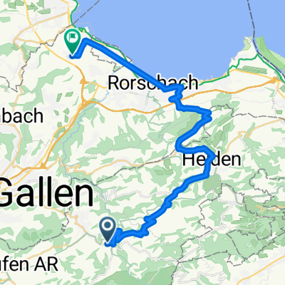
Overview
About this route
- -:--
- Duration
- 19.9 km
- Distance
- 151 m
- Ascent
- 639 m
- Descent
- ---
- Avg. speed
- ---
- Max. altitude

Route quality
Waytypes & surfaces along the route
Waytypes
Road
14.5 km
(73 %)
Cycleway
3 km
(15 %)
Surfaces
Paved
19.9 km
(100 %)
Asphalt
19.9 km
(100 %)
Continue with Bikemap
Use, edit, or download this cycling route
You would like to ride 2009_T8_Zum Bodensee, Nachmittag or customize it for your own trip? Here is what you can do with this Bikemap route:
Free features
- Save this route as favorite or in collections
- Copy & plan your own version of this route
- Sync your route with Garmin or Wahoo
Premium features
Free trial for 3 days, or one-time payment. More about Bikemap Premium.
- Navigate this route on iOS & Android
- Export a GPX / KML file of this route
- Create your custom printout (try it for free)
- Download this route for offline navigation
Discover more Premium features.
Get Bikemap PremiumFrom our community
Other popular routes starting in Trogen
 Trogen - Gäbris - Trogen
- Distance
- 10.2 km
- Ascent
- 425 m
- Descent
- 425 m
- Location
- Trogen, Canton of Appenzell Ausserrhoden, Switzerland
 trogen heide rorschach
- Distance
- 26.6 km
- Ascent
- 295 m
- Descent
- 830 m
- Location
- Trogen, Canton of Appenzell Ausserrhoden, Switzerland
 Suruggen Runde
- Distance
- 12.5 km
- Ascent
- 478 m
- Descent
- 478 m
- Location
- Trogen, Canton of Appenzell Ausserrhoden, Switzerland
 Niderenweg 12, Trogen nach Gartenstrasse 7, Güttingen
- Distance
- 43 km
- Ascent
- 283 m
- Descent
- 724 m
- Location
- Trogen, Canton of Appenzell Ausserrhoden, Switzerland
 Trogen Schwägalp
- Distance
- 39.3 km
- Ascent
- 1,001 m
- Descent
- 855 m
- Location
- Trogen, Canton of Appenzell Ausserrhoden, Switzerland
 Niderenweg 17, Trogen nach Bahnhofstrasse 23, Güttingen
- Distance
- 40.6 km
- Ascent
- 311 m
- Descent
- 761 m
- Location
- Trogen, Canton of Appenzell Ausserrhoden, Switzerland
 Mittelland Rundfahrt AR
- Distance
- 35.2 km
- Ascent
- 676 m
- Descent
- 675 m
- Location
- Trogen, Canton of Appenzell Ausserrhoden, Switzerland
 2009_T8_Zum Bodensee, Nachmittag
- Distance
- 19.9 km
- Ascent
- 151 m
- Descent
- 639 m
- Location
- Trogen, Canton of Appenzell Ausserrhoden, Switzerland
Open it in the app