

GF - 2020
A cycling route starting in Cota, Cundinamarca, Colombia.
Overview
About this route
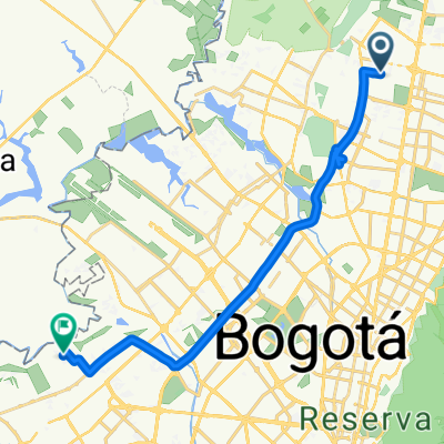
Bogotá-Macheta-Guatavita-Guasca-Sueva-La Calera-Bogotá
- -:--
- Duration
- 255.2 km
- Distance
- 3,477 m
- Ascent
- 3,446 m
- Descent
- ---
- Avg. speed
- ---
- Max. altitude

Continue with Bikemap
Use, edit, or download this cycling route
You would like to ride GF - 2020 or customize it for your own trip? Here is what you can do with this Bikemap route:
Free features
- Save this route as favorite or in collections
- Copy & plan your own version of this route
- Split it into stages to create a multi-day tour
- Sync your route with Garmin or Wahoo
Premium features
Free trial for 3 days, or one-time payment. More about Bikemap Premium.
- Navigate this route on iOS & Android
- Export a GPX / KML file of this route
- Create your custom printout (try it for free)
- Download this route for offline navigation
Discover more Premium features.
Get Bikemap PremiumFrom our community
Other popular routes starting in Cota
 Calle 167, Bogotá a Calle 186C Bis, Bogotá
- Distance
- 4.1 km
- Ascent
- 23 m
- Descent
- 29 m
- Location
- Cota, Cundinamarca, Colombia
 De Calle 127f # 93F-31 a Calle 127f # 93F-12
- Distance
- 64 km
- Ascent
- 607 m
- Descent
- 623 m
- Location
- Cota, Cundinamarca, Colombia
 vuelta
- Distance
- 5.7 km
- Ascent
- 64 m
- Descent
- 95 m
- Location
- Cota, Cundinamarca, Colombia
 Club de la montaña
- Distance
- 32.2 km
- Ascent
- 1,142 m
- Descent
- 1,141 m
- Location
- Cota, Cundinamarca, Colombia
 Carrera 56, Bogotá a Carrera 97F, Bogotá
- Distance
- 23 km
- Ascent
- 104 m
- Descent
- 127 m
- Location
- Cota, Cundinamarca, Colombia
 casa AG 50
- Distance
- 14.2 km
- Ascent
- 28 m
- Descent
- 20 m
- Location
- Cota, Cundinamarca, Colombia
 cota cundinamarca
- Distance
- 9.4 km
- Ascent
- 59 m
- Descent
- 58 m
- Location
- Cota, Cundinamarca, Colombia
 Avenida Carrera 104, Bogotá a Pinos de Lombardia, Bogotá
- Distance
- 6.9 km
- Ascent
- 25 m
- Descent
- 29 m
- Location
- Cota, Cundinamarca, Colombia
Open it in the app