

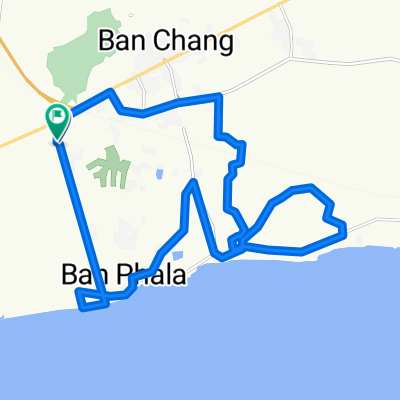
ชบ. 1003, Amphoe Sattahip to ชบ. 1003, Amphoe Sattahip
A cycling route starting in Ban Chang, Rayong, Thailand.
Overview
About this route
- 1 h 4 min
- Duration
- 17.4 km
- Distance
- 377 m
- Ascent
- 381 m
- Descent
- 16.3 km/h
- Avg. speed
- ---
- Max. altitude

Continue with Bikemap
Use, edit, or download this cycling route
You would like to ride ชบ. 1003, Amphoe Sattahip to ชบ. 1003, Amphoe Sattahip or customize it for your own trip? Here is what you can do with this Bikemap route:
Free features
- Save this route as favorite or in collections
- Copy & plan your own version of this route
- Sync your route with Garmin or Wahoo
Premium features
Free trial for 3 days, or one-time payment. More about Bikemap Premium.
- Navigate this route on iOS & Android
- Export a GPX / KML file of this route
- Create your custom printout (try it for free)
- Download this route for offline navigation
Discover more Premium features.
Get Bikemap PremiumFrom our community
Other popular routes starting in Ban Chang
 TH_Phala Beach - Chantaburi
- Distance
- 153.7 km
- Ascent
- 109 m
- Descent
- 113 m
- Location
- Ban Chang, Rayong, Thailand
 MTS Evening Ride
- Distance
- 21.2 km
- Ascent
- 99 m
- Descent
- 96 m
- Location
- Ban Chang, Rayong, Thailand
 MTS Solo Ride (2)
- Distance
- 43.4 km
- Ascent
- 145 m
- Descent
- 145 m
- Location
- Ban Chang, Rayong, Thailand
 ชบ. 1003, Amphoe Sattahip to ชบ. 1003, Amphoe Sattahip
- Distance
- 17.4 km
- Ascent
- 377 m
- Descent
- 381 m
- Location
- Ban Chang, Rayong, Thailand
 Ban Chang-Plutaluang-Silver Lake-332-Ban Chang
- Distance
- 54.9 km
- Ascent
- 256 m
- Descent
- 253 m
- Location
- Ban Chang, Rayong, Thailand
 MTS Solo Route
- Distance
- 32.5 km
- Ascent
- 100 m
- Descent
- 97 m
- Location
- Ban Chang, Rayong, Thailand
 4 June 2014
- Distance
- 92 km
- Ascent
- 339 m
- Descent
- 341 m
- Location
- Ban Chang, Rayong, Thailand
 Hokien Noodles/Brookside Ride
- Distance
- 140.7 km
- Ascent
- 247 m
- Descent
- 248 m
- Location
- Ban Chang, Rayong, Thailand
Open it in the app