LOIRA EST
A cycling route starting in Saint-Cyr-sur-Loire, Centre Region, France.
Overview
About this route
- -:--
- Duration
- 142.4 km
- Distance
- 225 m
- Ascent
- 222 m
- Descent
- ---
- Avg. speed
- ---
- Avg. speed
Route quality
Waytypes & surfaces along the route
Waytypes
Busy road
56.3 km
(40 %)
Quiet road
41.3 km
(29 %)
Surfaces
Paved
60.8 km
(43 %)
Unpaved
1.8 km
(1 %)
Asphalt
58.8 km
(41 %)
Concrete
1.7 km
(1 %)
Route highlights
Points of interest along the route
Point of interest after 8.5 km
Cantina Vino
Point of interest after 27 km
Amboise Castle
Point of interest after 38.6 km
Chenonceaux Castle
Point of interest after 77.3 km
Cheverny Castle
Point of interest after 92.8 km
Chambord Castle
Continue with Bikemap
Use, edit, or download this cycling route
You would like to ride LOIRA EST or customize it for your own trip? Here is what you can do with this Bikemap route:
Free features
- Save this route as favorite or in collections
- Copy & plan your own version of this route
- Sync your route with Garmin or Wahoo
Premium features
Free trial for 3 days, or one-time payment. More about Bikemap Premium.
- Navigate this route on iOS & Android
- Export a GPX / KML file of this route
- Create your custom printout (try it for free)
- Download this route for offline navigation
Discover more Premium features.
Get Bikemap PremiumFrom our community
Other popular routes starting in Saint-Cyr-sur-Loire
- De Rue de Montrésor 10, Saint-Cyr-sur-Loire à Rue de Montrésor 10, Saint-Cyr-sur-Loire
- Distance
- 29.9 km
- Ascent
- 149 m
- Descent
- 156 m
- Location
- Saint-Cyr-sur-Loire, Centre Region, France
- De Allée des Acacias 51, Saint-Cyr-sur-Loire à Rue des 4 Chesneaux 9, Souzay-Champigny
- Distance
- 69.4 km
- Ascent
- 264 m
- Descent
- 333 m
- Location
- Saint-Cyr-sur-Loire, Centre Region, France
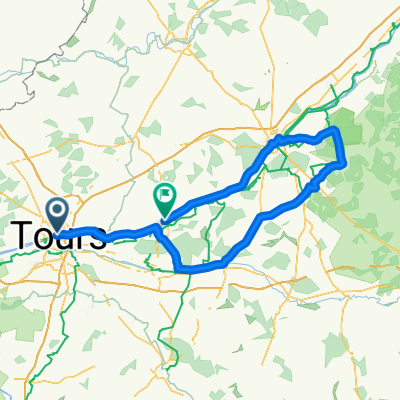
- Loire à vélo - Etape 1
- Distance
- 99.2 km
- Ascent
- 517 m
- Descent
- 581 m
- Location
- Saint-Cyr-sur-Loire, Centre Region, France
- Saint Cyr sur Loire - Chenonceaux
- Distance
- 54.3 km
- Ascent
- 1,707 m
- Descent
- 1,747 m
- Location
- Saint-Cyr-sur-Loire, Centre Region, France
- 1993_Tours_St.Malo_Tours
- Distance
- 946.1 km
- Ascent
- 3,754 m
- Descent
- 3,721 m
- Location
- Saint-Cyr-sur-Loire, Centre Region, France
- De 10 Allée de Loches, Saint-Cyr-sur-Loire à 9 Allée de Loches, Saint-Cyr-sur-Loire
- Distance
- 6.3 km
- Ascent
- 66 m
- Descent
- 65 m
- Location
- Saint-Cyr-sur-Loire, Centre Region, France
- Tours - Pontamailly (Loire)
- Distance
- 447.9 km
- Ascent
- 447 m
- Descent
- 298 m
- Location
- Saint-Cyr-sur-Loire, Centre Region, France
- LOIRA EST
- Distance
- 142.4 km
- Ascent
- 225 m
- Descent
- 222 m
- Location
- Saint-Cyr-sur-Loire, Centre Region, France
Open it in the app