TOSCANA_108_2883_paolopagni_Castelnuovo, San Pellegrino in Alpe, Orecchiella, Gramolazzo, Campocatino
- 108 km
- 2,670 m
- 2,654 m
- Castelnuovo di Garfagnana, Tuscany, Italy
A cycling route starting in Castelnuovo di Garfagnana, Tuscany, Italy.
Overview
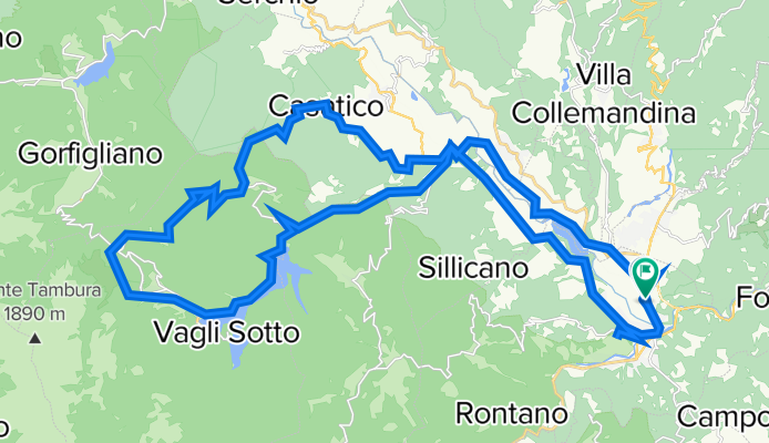
giro mtb anticlockwise. We start from Castelnuovo station, we reach Pontecosi crossing the magnificent medieval bridge, we ride up towards Poggio with the spectacular passage over the railway bridge of Villetta San Romano. From Poggio we reach Roccalberti, then Vitoio and Casatico. Now we face the most challenging section of the tour: 6 km of climbing on a dirt road to get to Roggio and another 4 before returning to asphalt a couple of kilometers before Campocatino and the magnificent Oasi (a wonderful place above Lake Vagli at about 1000 meters altitude with a spectacular view: the mountains all around, the meadows, the valley below with the lake and many stone houses, originally used by shepherds and now partly restored as holiday homes). We take a descending path of about 1 km and arrive at Vagli Sopra, then reach Fontana delle Monache and Lake Vagli (an artificial basin that was emptied every ten years for maintenance work and reveals an old village located at the bottom of the valley; the emptying has not occurred since 1994, but it seems that the "emptying" should take place in 2021). We follow the basin on the left bank, then, with a slight uphill, we are back at the village of Poggio. We turn towards Castelnuovo along the SR della Garfagnana. When we are a couple of km from Castelnuovo, we turn right to visit the Fortress of Mont'Alfonso. We turn back, pass through Castelnuovo and reach the FS station.
created this 5 years ago
Route quality
Road
12.9 km
(28 %)
Quiet road
11.1 km
(24 %)
Paved
23.5 km
(51 %)
Unpaved
12 km
(26 %)
Asphalt
23 km
(50 %)
Ground
7.4 km
(16 %)
Continue with Bikemap
You would like to ride Castelnuovo Garfagnana-Poggio-Campocatino-Lago di Vagli-Castelnuovo G. or customize it for your own trip? Here is what you can do with this Bikemap route:
Free trial for 3 days, or one-time payment. More about Bikemap Premium.
Discover more Premium features.
Get Bikemap PremiumFrom our community
Open it in the app