

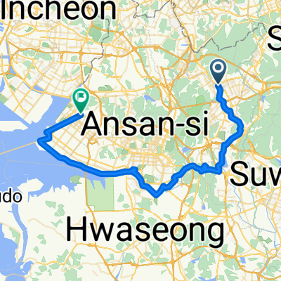
쌍개울(안양)To오이도역(시흥)
A cycling route starting in Anyang-si, Gyeonggi-do, Republic of Korea.
Overview
About this route
- 4 h 40 min
- Duration
- 54.7 km
- Distance
- 85 m
- Ascent
- 115 m
- Descent
- 11.7 km/h
- Avg. speed
- ---
- Max. altitude

Continue with Bikemap
Use, edit, or download this cycling route
You would like to ride 쌍개울(안양)To오이도역(시흥) or customize it for your own trip? Here is what you can do with this Bikemap route:
Free features
- Save this route as favorite or in collections
- Copy & plan your own version of this route
- Sync your route with Garmin or Wahoo
Premium features
Free trial for 3 days, or one-time payment. More about Bikemap Premium.
- Navigate this route on iOS & Android
- Export a GPX / KML file of this route
- Create your custom printout (try it for free)
- Download this route for offline navigation
Discover more Premium features.
Get Bikemap PremiumFrom our community
Other popular routes starting in Anyang-si
 쌍개울(안양)To오이도역(시흥)
- Distance
- 54.7 km
- Ascent
- 85 m
- Descent
- 115 m
- Location
- Anyang-si, Gyeonggi-do, Republic of Korea
 산본동, 군포시에서 산본동, 군포시까지
- Distance
- 15.4 km
- Ascent
- 212 m
- Descent
- 186 m
- Location
- Anyang-si, Gyeonggi-do, Republic of Korea
 의왕시 - 당산역
- Distance
- 33.9 km
- Ascent
- 119 m
- Descent
- 157 m
- Location
- Anyang-si, Gyeonggi-do, Republic of Korea
 안양 - 소레포구
- Distance
- 33.2 km
- Ascent
- 325 m
- Descent
- 344 m
- Location
- Anyang-si, Gyeonggi-do, Republic of Korea
 수원(월성호 - 서호)
- Distance
- 63.3 km
- Ascent
- 444 m
- Descent
- 441 m
- Location
- Anyang-si, Gyeonggi-do, Republic of Korea
![비산동Ph0]으로 라우팅](https://www.bikemap.net/media/temp/routes_gallery/fb1e8679-cd1e-457c-80db-81fc167fcbdf.jpg) 비산동Ph0]으로 라우팅
비산동Ph0]으로 라우팅- Distance
- 7.7 km
- Ascent
- 251 m
- Descent
- 265 m
- Location
- Anyang-si, Gyeonggi-do, Republic of Korea
 석수동 679-1, 안양시 to 여의동 85-6
- Distance
- 26.3 km
- Ascent
- 10 m
- Descent
- 34 m
- Location
- Anyang-si, Gyeonggi-do, Republic of Korea
 test
test- Distance
- 0.8 km
- Ascent
- 12 m
- Descent
- 74 m
- Location
- Anyang-si, Gyeonggi-do, Republic of Korea
Open it in the app