
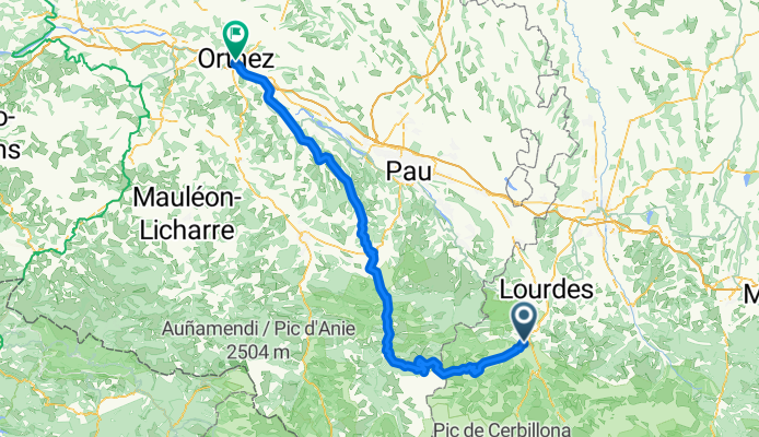
Argelès-Gazost - Orthez
A cycling route starting in Argelès-Gazost, Occitanie, France.
Overview
About this route
- Etappe Pyrenäen 2012
- -:--
- Duration
- 116.5 km
- Distance
- 2,596 m
- Ascent
- 2,970 m
- Descent
- ---
- Avg. speed
- ---
- Max. altitude
Route quality
Waytypes & surfaces along the route
Waytypes
Road
33.8 km
(29 %)
Quiet road
1.2 km
(1 %)
Surfaces
Paved
102.5 km
(88 %)
Asphalt
102.5 km
(88 %)
Undefined
14 km
(12 %)
Continue with Bikemap
Use, edit, or download this cycling route
You would like to ride Argelès-Gazost - Orthez or customize it for your own trip? Here is what you can do with this Bikemap route:
Free features
- Save this route as favorite or in collections
- Copy & plan your own version of this route
- Split it into stages to create a multi-day tour
- Sync your route with Garmin or Wahoo
Premium features
Free trial for 3 days, or one-time payment. More about Bikemap Premium.
- Navigate this route on iOS & Android
- Export a GPX / KML file of this route
- Create your custom printout (try it for free)
- Download this route for offline navigation
Discover more Premium features.
Get Bikemap PremiumFrom our community
Other popular routes starting in Argelès-Gazost
 Argeles Gazost-Col Spandelles-Col de Soulor
- Distance
- 58.6 km
- Ascent
- 1,756 m
- Descent
- 1,764 m
- Location
- Argelès-Gazost, Occitanie, France
 2016 Ride Day 49 - Argelès-Gazost to Cauterets and Return
- Distance
- 35.1 km
- Ascent
- 660 m
- Descent
- 660 m
- Location
- Argelès-Gazost, Occitanie, France
 2016 Ride Day 52 - Argelès-Gazost to Bagnères-de-Bigorre
- Distance
- 40.6 km
- Ascent
- 540 m
- Descent
- 523 m
- Location
- Argelès-Gazost, Occitanie, France
 V13 Col de Couraduque
- Distance
- 16.3 km
- Ascent
- 963 m
- Descent
- 40 m
- Location
- Argelès-Gazost, Occitanie, France
 2016 Ride Day 51 - Argelès-Gazost to Gèdre
- Distance
- 63.8 km
- Ascent
- 818 m
- Descent
- 815 m
- Location
- Argelès-Gazost, Occitanie, France
 Pirenei_libro_04_mar25
- Distance
- 114.7 km
- Ascent
- 3,020 m
- Descent
- 2,824 m
- Location
- Argelès-Gazost, Occitanie, France
 V12 Hautacam
- Distance
- 23.4 km
- Ascent
- 1,298 m
- Descent
- 177 m
- Location
- Argelès-Gazost, Occitanie, France
 **14-S. Argelès-Gazost - Lac de Cap Long (136,5 Km)
- Distance
- 136.3 km
- Ascent
- 5,080 m
- Descent
- 3,641 m
- Location
- Argelès-Gazost, Occitanie, France
Open it in the app