

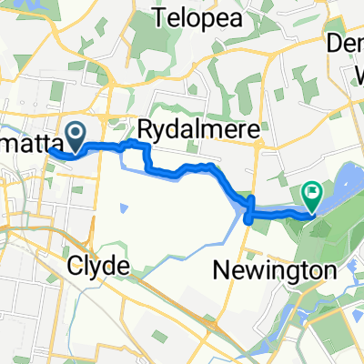
Parramatta - historical walk - 16 km
A cycling route starting in Harris Park, New South Wales, Australia.
Overview
About this route
- -:--
- Duration
- 15.8 km
- Distance
- 146 m
- Ascent
- 145 m
- Descent
- ---
- Avg. speed
- 32 m
- Max. altitude

Route highlights
Points of interest along the route
Point of interest after 3.3 km
Government Farm (colony's first successful farm).
Point of interest after 3.6 km
Parramatta River. Original settlement accessible by river.
Point of interest after 3.7 km
The Crescent - natural ampitheatre.
Point of interest after 3.8 km
Redoubt (Fortified Camp).
Point of interest after 4.1 km
Bridge Street - traces of old road.
Point of interest after 4.3 km
George Street - remains of road surfaces, pavements, footings.
Point of interest after 4.4 km
Lady Fitzroy Memorial.
Point of interest after 4.4 km
Convict Huts (demolished).
Point of interest after 4.6 km
Settlement at Rose Hill.
Point of interest after 5 km
Aboriginal Landscape - ridgeline of The Crescent and around Domain Creek.
Point of interest after 5.2 km
Phillip's Government House and Carriage Drive.
Point of interest after 5.3 km
Bath House.
Point of interest after 5.3 km
Observatory Transit Stones.
Point of interest after 5.5 km
Boer War Memorial and Canon.
Point of interest after 5.6 km
Billy Hart Memorial (William (Billy) E. Hart)
Point of interest after 7 km
Dairy Cottage and Sunken Milk Room.
Point of interest after 9.9 km
Little Cogee.
Point of interest after 10.5 km
Park Gate House - Ross Street (was Macquarie Street).
Point of interest after 12 km
Park Gate House - George Street Gatehouse.
Continue with Bikemap
Use, edit, or download this cycling route
You would like to ride Parramatta - historical walk - 16 km or customize it for your own trip? Here is what you can do with this Bikemap route:
Free features
- Save this route as favorite or in collections
- Copy & plan your own version of this route
- Sync your route with Garmin or Wahoo
Premium features
Free trial for 3 days, or one-time payment. More about Bikemap Premium.
- Navigate this route on iOS & Android
- Export a GPX / KML file of this route
- Create your custom printout (try it for free)
- Download this route for offline navigation
Discover more Premium features.
Get Bikemap PremiumFrom our community
Other popular routes starting in Harris Park
 run
run- Distance
- 4.3 km
- Ascent
- 116 m
- Descent
- 94 m
- Location
- Harris Park, New South Wales, Australia
 ENb, Parramatta to ENb, Parramatta
- Distance
- 4.9 km
- Ascent
- 19 m
- Descent
- 18 m
- Location
- Harris Park, New South Wales, Australia
 Parramatta - historical walk - 16 km
- Distance
- 15.8 km
- Ascent
- 146 m
- Descent
- 145 m
- Location
- Harris Park, New South Wales, Australia
 36 Cowper St, Harris Park to 36 Cowper St, Parramatta
- Distance
- 19.6 km
- Ascent
- 86 m
- Descent
- 89 m
- Location
- Harris Park, New South Wales, Australia
 93 Thomas St, Parramatta to James Ruse Drive, Parramatta
- Distance
- 27 km
- Ascent
- 195 m
- Descent
- 195 m
- Location
- Harris Park, New South Wales, Australia
 Steady ride in Sydney Olympic Park
- Distance
- 7 km
- Ascent
- 63 m
- Descent
- 66 m
- Location
- Harris Park, New South Wales, Australia
 Easy ride in Harris Park
- Distance
- 24.6 km
- Ascent
- 0 m
- Descent
- 14 m
- Location
- Harris Park, New South Wales, Australia
 2 Allen St, Harris Park to 104 Victoria Rd, North Parramatta
- Distance
- 3.5 km
- Ascent
- 28 m
- Descent
- 37 m
- Location
- Harris Park, New South Wales, Australia
Open it in the app