

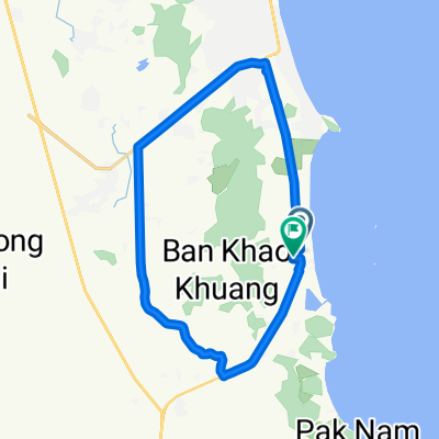
Nong Kae-Takiap 21/14, Tambon Nong Kae to Unnamed Road, Tambon Nong Kae
A cycling route starting in Hua Hin, Prachuap Khiri Khan, Thailand.
Overview
About this route
- 1 h 54 min
- Duration
- 42.1 km
- Distance
- 181 m
- Ascent
- 178 m
- Descent
- 22.2 km/h
- Avg. speed
- ---
- Max. altitude

Route quality
Waytypes & surfaces along the route
Waytypes
Road
19.4 km
(46 %)
Cycleway
12.6 km
(30 %)
Surfaces
Paved
19.4 km
(46 %)
Asphalt
15.6 km
(37 %)
Concrete
2.9 km
(7 %)
Continue with Bikemap
Use, edit, or download this cycling route
You would like to ride Nong Kae-Takiap 21/14, Tambon Nong Kae to Unnamed Road, Tambon Nong Kae or customize it for your own trip? Here is what you can do with this Bikemap route:
Free features
- Save this route as favorite or in collections
- Copy & plan your own version of this route
- Sync your route with Garmin or Wahoo
Premium features
Free trial for 3 days, or one-time payment. More about Bikemap Premium.
- Navigate this route on iOS & Android
- Export a GPX / KML file of this route
- Create your custom printout (try it for free)
- Download this route for offline navigation
Discover more Premium features.
Get Bikemap PremiumFrom our community
Other popular routes starting in Hua Hin
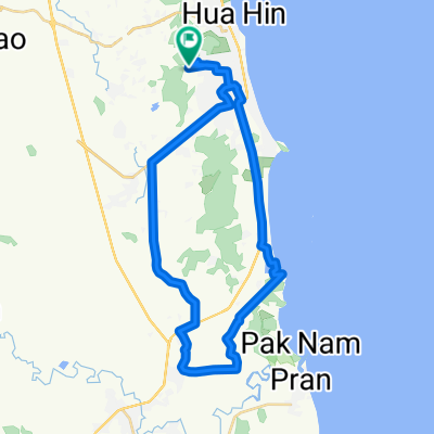
 Hua Hin northern
- Distance
- 42.3 km
- Ascent
- 100 m
- Descent
- 116 m
- Location
- Hua Hin, Prachuap Khiri Khan, Thailand
 Hua Hin Cycling
- Distance
- 29.1 km
- Ascent
- 53 m
- Descent
- 46 m
- Location
- Hua Hin, Prachuap Khiri Khan, Thailand
 маршрут из Phet Kasem Road
- Distance
- 48 km
- Ascent
- 207 m
- Descent
- 220 m
- Location
- Hua Hin, Prachuap Khiri Khan, Thailand
 Nong Kae-Takiap 21/14, Tambon Nong Kae to Unnamed Road, Tambon Nong Kae
- Distance
- 42.1 km
- Ascent
- 181 m
- Descent
- 178 m
- Location
- Hua Hin, Prachuap Khiri Khan, Thailand
 Hua Hin - Tha Yang - Hua Hin 2
- Distance
- 117 km
- Ascent
- 66 m
- Descent
- 65 m
- Location
- Hua Hin, Prachuap Khiri Khan, Thailand
 Round around Hua Hin 88
- Distance
- 41.7 km
- Ascent
- 112 m
- Descent
- 120 m
- Location
- Hua Hin, Prachuap Khiri Khan, Thailand
 Moderate route in Hua Hin
- Distance
- 49.2 km
- Ascent
- 150 m
- Descent
- 156 m
- Location
- Hua Hin, Prachuap Khiri Khan, Thailand
 Hua Hin-Khao Tao
- Distance
- 43.2 km
- Ascent
- 93 m
- Descent
- 100 m
- Location
- Hua Hin, Prachuap Khiri Khan, Thailand
Open it in the app