Lemnitz - Elstertrebnitz
- 630 km
- 4,642 m
- 5,423 m
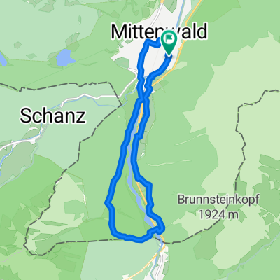
- Mittenwald, Bavaria, Germany
Anforderung: Leichte E-Bike-Tour. Für alle Fitnesslevel. Grundkenntnisse der Fahrtechnik ausreichend. Ausschließlich asphaltierte Wege.
Tourbeschreibung: Umfahrung des Garmisch-Partenkirchner Kessels durch Wiesen und an der Loisach entlang, mit schönen Blick auf die umliegenden Berge und Besuch der innerörtlichen Zentren von Garmisch und Partenkirchen.
Streckenbeschreibung: Vom Hotel aus fahren wir auf der Straße nach Klais und biegen dort in der Ortsmitte nach links Richtung Bahnhof ab. Von hier folgen wir dem Radweg bis zum Ortseingang von Garmisch-Partenkirchen. Am Ende des Radwegs überqueren wir die Bundesstraße und fahren zur vor uns liegenden Skisprungschanze. Kurz nach dem Bahnübergang biegen wir nach rechts auf einen Radweg ab und folgen diesen ca. 4 Km neben der Bahnlinie. Am fünften Bahnübergang orientieren wir uns rechtsseitig auf der Kreuzeckbahnstraße Richtung Zugspitzstraße, überqueren die Loisach und folgen der Äußeren Maximilianstraße. Bei nächster Möglichkeiten nehmen wir den gut erkennbaren Weg an der Loisach. Wir orientieren uns am nächsten Kirchturm und kommen so in den Fußgängerbereich von Garmisch. Danach geht es am Bahnhof vorbei Richtung Partenkirchen. Nach Durchfahrt der historischen Ludwigstraße führt uns die Tour links haltend über die Gsteigstraße, oberhalb des auf dem Hinweg benutzen Radweges, wieder Richtung Klais und von dort über die Mautstraße zum Hotel.

Quiet road
15.6 km42 %Track
10 km27 %Paved
34.2 km(92 %)Unpaved
1.1 km(3 %)Asphalt
33.5 km90 %Paved (undefined)
0.7 km2 %Skistadion
Partnachklamm
Free trial for 3 days, or one-time payment. More about Bikemap Premium.
Discover more Premium features.
Get Bikemap PremiumOpen it in the app