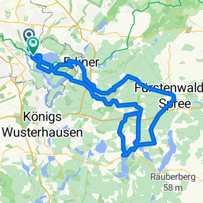
2021 Spreewald Tag 3: Version 2 Köpenick - Müggelsee - Neue Mühle, 37 km
A cycling route starting in Köpenick, State of Berlin, Germany.
Overview
About this route
Version Jürgen Bunge
- -:--
- Duration
- 37.3 km
- Distance
- 160 m
- Ascent
- 160 m
- Descent
- ---
- Avg. speed
- ---
- Max. altitude
Route quality
Waytypes & surfaces along the route
Waytypes
Quiet road
10.1 km
(27 %)
Pedestrian area
9.3 km
(25 %)
Surfaces
Paved
25.7 km
(69 %)
Unpaved
3.4 km
(9 %)
Asphalt
24.2 km
(65 %)
Concrete
1.5 km
(4 %)
Route highlights
Points of interest along the route
Point of interest after 4.7 km
Café Rübezahl am Müggelsee
Point of interest after 4.7 km
Spreetunnel Achtung! Treppen.
Point of interest after 28.1 km
Kindergarten "Kleine Pfefferkörner"
Continue with Bikemap
Use, edit, or download this cycling route
You would like to ride 2021 Spreewald Tag 3: Version 2 Köpenick - Müggelsee - Neue Mühle, 37 km or customize it for your own trip? Here is what you can do with this Bikemap route:
Free features
- Save this route as favorite or in collections
- Copy & plan your own version of this route
- Sync your route with Garmin or Wahoo
Premium features
Free trial for 3 days, or one-time payment. More about Bikemap Premium.
- Navigate this route on iOS & Android
- Export a GPX / KML file of this route
- Create your custom printout (try it for free)
- Download this route for offline navigation
Discover more Premium features.
Get Bikemap PremiumFrom our community
Other popular routes starting in Köpenick
Berlin -Usedom zu zu viert.- Distance
- 273.6 km
- Ascent
- 253 m
- Descent
- 286 m
- Location
- Köpenick, State of Berlin, Germany
Rund um den Müggelsee- Distance
- 38.2 km
- Ascent
- 620 m
- Descent
- 595 m
- Location
- Köpenick, State of Berlin, Germany
2021 Spreewald Tag 3: Version 2 Köpenick - Müggelsee - Neue Mühle, 37 km- Distance
- 37.3 km
- Ascent
- 160 m
- Descent
- 160 m
- Location
- Köpenick, State of Berlin, Germany
Ersatzrunde für Rund um den Scharmützelsee- Distance
- 134.6 km
- Ascent
- 353 m
- Descent
- 349 m
- Location
- Köpenick, State of Berlin, Germany
Dahme Radweg2- Distance
- 89.6 km
- Ascent
- 129 m
- Descent
- 100 m
- Location
- Köpenick, State of Berlin, Germany
Ost- und Randberliner Wasser-Tour- Distance
- 62.9 km
- Ascent
- 89 m
- Descent
- 91 m
- Location
- Köpenick, State of Berlin, Germany
Müggelsee Sturzrunde- Distance
- 32.8 km
- Ascent
- 64 m
- Descent
- 66 m
- Location
- Köpenick, State of Berlin, Germany
Route in Berlin- Distance
- 43.8 km
- Ascent
- 162 m
- Descent
- 164 m
- Location
- Köpenick, State of Berlin, Germany
Open it in the app


