
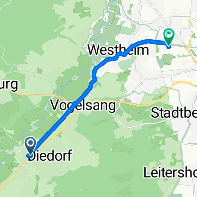
Diedorf - Angerhütte
A cycling route starting in Diedorf, Bavaria, Germany.
Overview
About this route
<span style="font-size: 8pt;">Diedorf</span>
<span style="font-size: 8pt;">Gessertshausen<span> </span>121</span>
<span style="font-size: 8pt;"> </span>
<span style="font-size: 8pt;">Margertshausen</span>
<span style="font-size: 8pt;">Fischach</span>
<span style="font-size: 8pt;">Wollmetshofen</span>
<span style="font-size: 8pt;">Langenneufnach</span>
<span style="font-size: 8pt;">Walkertshofen</span>
<span style="font-size: 8pt;">Reichertshofen</span>
<span style="font-size: 8pt;">Mittelneufnach</span>
<span style="font-size: 8pt;">Oberneufnach</span>
<span style="font-size: 8pt;">Marktwald</span>
<span style="font-size: 8pt;"> </span>
<span style="font-size: 8pt;">Tussenhausen<span> </span>88</span>
<span style="font-size: 8pt;"> </span>
<span style="font-size: 8pt;">Mattsies</span>
<span style="font-size: 8pt;"> </span>
<span style="font-size: 8pt;">Mindelheim<span> </span>79</span>
<span style="font-size: 8pt;"> </span>
<span style="font-size: 8pt;">Apfeltrach</span>
<span style="font-size: 8pt;">Dirlewang</span>
<span style="font-size: 8pt;">Unteregg</span>
<span style="font-size: 8pt;">Oberegg</span>
<span style="font-size: 8pt;">Rappen</span>
<span style="font-size: 8pt;">Sonderhof</span>
<span style="font-size: 8pt;">Neeuried</span>
<span style="font-size: 8pt;">Hahnenbühl</span>
<span style="font-size: 8pt;">Wolfs</span>
<span style="font-size: 8pt;"> </span>
<span style="font-size: 8pt;">Obergünzburg<span> </span>52</span><span style="font-size: 8pt;"></span>
<span style="font-size: 8pt;"> </span>
<span style="font-size: 8pt;">Immenthal</span>
<span style="font-size: 8pt;">Sellthüren</span>
<span style="font-size: 8pt;">Eufnach</span>
<span style="font-size: 8pt;">Ellenberg</span>
<span style="font-size: 8pt;">Wildpoldsried</span>
<span style="font-size: 8pt;">Bogenried</span>
<span style="font-size: 8pt;"> </span>
<span style="font-size: 8pt;">Betzigau<span> </span>37</span>
<span style="font-size: 8pt;"> </span>
<span style="font-size: 8pt;">Mühlstatt</span>
<span style="font-size: 8pt;">Haßberg</span>
<span style="font-size: 8pt;">Fahls</span>
<span style="font-size: 8pt;"> </span>
<span style="font-size: 8pt;">Durach<span> </span>32</span>
<span style="font-size: 8pt;"> </span>
<span style="font-size: 8pt;">Seebach</span>
<span style="font-size: 8pt;">Sulzberg</span>
<span style="font-size: 8pt;">Kenels</span>
<span style="font-size: 8pt;">Ottacker</span>
<span style="font-size: 8pt;">Rottach</span>
<span style="font-size: 8pt;">Humbach</span>
<span style="font-size: 8pt;">Greggenhofen</span>
<span style="font-size: 8pt;">Rauhenzell</span>
<span style="font-size: 8pt;">Altmummen</span>
<span style="font-size: 8pt;">Tanne</span>
<span style="font-size: 8pt;">Ettensberg</span>
<span style="font-size: 8pt;"> </span>
<span style="font-size: 8pt;">Gunzesried<span> </span>4</span>
<span style="font-size: 8pt;">Angerhütte</span>
- -:--
- Duration
- 133.4 km
- Distance
- 1,026 m
- Ascent
- 765 m
- Descent
- ---
- Avg. speed
- 857 m
- Max. altitude

Route quality
Waytypes & surfaces along the route
Waytypes
Road
41.4 km
(31 %)
Quiet road
40 km
(30 %)
Surfaces
Paved
94.7 km
(71 %)
Unpaved
2.7 km
(2 %)
Asphalt
94.7 km
(71 %)
Unpaved (undefined)
1.3 km
(1 %)
Route highlights
Points of interest along the route
Point of interest after 0.1 km
Continue with Bikemap
Use, edit, or download this cycling route
You would like to ride Diedorf - Angerhütte or customize it for your own trip? Here is what you can do with this Bikemap route:
Free features
- Save this route as favorite or in collections
- Copy & plan your own version of this route
- Split it into stages to create a multi-day tour
- Sync your route with Garmin or Wahoo
Premium features
Free trial for 3 days, or one-time payment. More about Bikemap Premium.
- Navigate this route on iOS & Android
- Export a GPX / KML file of this route
- Create your custom printout (try it for free)
- Download this route for offline navigation
Discover more Premium features.
Get Bikemap PremiumFrom our community
Other popular routes starting in Diedorf
 Sonnige Reischenau
- Distance
- 50.3 km
- Ascent
- 235 m
- Descent
- 238 m
- Location
- Diedorf, Bavaria, Germany
 Diedorf-Engelshof-Fischach-Diedorf
- Distance
- 39.6 km
- Ascent
- 280 m
- Descent
- 279 m
- Location
- Diedorf, Bavaria, Germany
 Diedorf-Augsburg
- Distance
- 6.6 km
- Ascent
- 42 m
- Descent
- 31 m
- Location
- Diedorf, Bavaria, Germany
 Diedorf-Augsburg Hamerschmiede-Augsburg Innenstadt-Diedorf
- Distance
- 41.1 km
- Ascent
- 102 m
- Descent
- 104 m
- Location
- Diedorf, Bavaria, Germany
 Staudenrundtour nach Bobingen und zurück
- Distance
- 44.1 km
- Ascent
- 306 m
- Descent
- 304 m
- Location
- Diedorf, Bavaria, Germany
 Diedorf - Angerhütte
- Distance
- 133.4 km
- Ascent
- 1,026 m
- Descent
- 765 m
- Location
- Diedorf, Bavaria, Germany
 Burgwalden
- Distance
- 18 km
- Ascent
- 104 m
- Descent
- 103 m
- Location
- Diedorf, Bavaria, Germany
 Waldidyllen
- Distance
- 53.4 km
- Ascent
- 873 m
- Descent
- 869 m
- Location
- Diedorf, Bavaria, Germany
Open it in the app