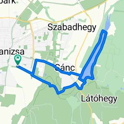
Obornak_Várdomb
A cycling route starting in Nagykanizsa, Zala, Hungary.
Overview
About this route
JĂł állapotĂş szilárd burkolatĂş erdĂ©szeti Ăşt, majd stabilizált Ăşt. Beavatkozást nem igĂ©nyel, legfeljebb lokális javĂtás "C" A domb felsĹ‘ rĂ©sze, a volt lokátor állomás szemĂ©ttelep.
- -:--
- Duration
- 3.7 km
- Distance
- 136 m
- Ascent
- 8 m
- Descent
- ---
- Avg. speed
- 328 m
- Max. altitude
Route quality
Waytypes & surfaces along the route
Waytypes
Track
3.7 km
(100 %)
Surfaces
Unpaved
1.5 km
(40 %)
Ground
1.5 km
(40 %)
Undefined
2.2 km
(60 %)
Route highlights
Points of interest along the route
Point of interest after 2 km
Aszfalt vége
Point of interest after 3 km
nem létező út sárga 0
Continue with Bikemap
Use, edit, or download this cycling route
You would like to ride Obornak_Várdomb or customize it for your own trip? Here is what you can do with this Bikemap route:
Free features
- Save this route as favorite or in collections
- Copy & plan your own version of this route
- Sync your route with Garmin or Wahoo
Premium features
Free trial for 3 days, or one-time payment. More about Bikemap Premium.
- Navigate this route on iOS & Android
- Export a GPX / KML file of this route
- Create your custom printout (try it for free)
- Download this route for offline navigation
Discover more Premium features.
Get Bikemap PremiumFrom our community
Other popular routes starting in Nagykanizsa
- Tengerre magyar 1.st day
- Distance
- 174.9 km
- Ascent
- 410 m
- Descent
- 437 m
- Location
- Nagykanizsa, Zala, Hungary
- Börzönce1
- Distance
- 65.4 km
- Ascent
- 327 m
- Descent
- 327 m
- Location
- Nagykanizsa, Zala, Hungary
- Obornak Várdomb kör
- Distance
- 14.7 km
- Ascent
- 343 m
- Descent
- 349 m
- Location
- Nagykanizsa, Zala, Hungary
- Látóhegy - Gáspár-hegy - Nagyrécse - Bacónaki-hegy - Cserfő
- Distance
- 33.4 km
- Ascent
- 391 m
- Descent
- 390 m
- Location
- Nagykanizsa, Zala, Hungary
- Mórichelyi kör
- Distance
- 31 km
- Ascent
- 402 m
- Descent
- 402 m
- Location
- Nagykanizsa, Zala, Hungary
- Murafölde kör 2
- Distance
- 222 km
- Ascent
- 3,042 m
- Descent
- 3,043 m
- Location
- Nagykanizsa, Zala, Hungary
- Murafölde kör 3
- Distance
- 219.8 km
- Ascent
- 2,889 m
- Descent
- 2,891 m
- Location
- Nagykanizsa, Zala, Hungary
- Vörös-hegyi kör
- Distance
- 33.1 km
- Ascent
- 197 m
- Descent
- 203 m
- Location
- Nagykanizsa, Zala, Hungary
Open it in the app