

Kasperer - Runde
A cycling route starting in Brixen, Trentino-Alto Adige, Italy.
Overview
About this route
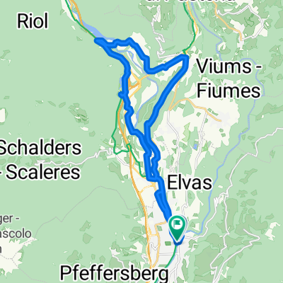
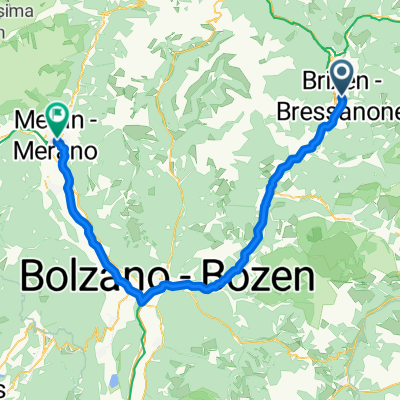
From Brixen northwards to Neustift, parallel to the state road towards Schabs. Cross the state road to Schabs and head towards Köferersiedlung, here again northwards and on the forest path to the craftsman zone Förche to Schabs. Again on the road to Spinges and from there the forest path to the Anrather hut and the Jochtal house. At Jochtal towards Mauls. Here comes a carrying section of about 10-20 minutes, then just downhill towards Mauls. Make sure to stop at Kasperer in the middle. Homemade food of the highest quality after the effort. Continue to Mauls and there about 150 m northwards and then cross the river and under the motorway onto the Eisacktaler bike path, following it south (unfortunately not well marked on the map - missing). I suggest using the bike path at Mittewald until it crosses the state road, here however return to the road because the setup of the bike path is not ideal. From Franzensfeste back onto the bike path and follow it along to Lake Vahrner. here stay on the right side of the motorway and through the woods to Vahrn. On secondary roads, you get to Brixen. The final station - almost a must - is the beer garden of Hotel Senoner - top quality pils enjoyment.
- -:--
- Duration
- 58.6 km
- Distance
- 1,520 m
- Ascent
- 1,517 m
- Descent
- ---
- Avg. speed
- ---
- Max. altitude

Route highlights
Points of interest along the route
Point of interest after 21.3 km
Anrater Hütte
Point of interest after 23.1 km
Jochtal - Vals Höchster Punkt
Point of interest after 28.3 km
Gasthof Kasperer
Continue with Bikemap
Use, edit, or download this cycling route
You would like to ride Kasperer - Runde or customize it for your own trip? Here is what you can do with this Bikemap route:
Free features
- Save this route as favorite or in collections
- Copy & plan your own version of this route
- Sync your route with Garmin or Wahoo
Premium features
Free trial for 3 days, or one-time payment. More about Bikemap Premium.
- Navigate this route on iOS & Android
- Export a GPX / KML file of this route
- Create your custom printout (try it for free)
- Download this route for offline navigation
Discover more Premium features.
Get Bikemap PremiumFrom our community
Other popular routes starting in Brixen
 🚴♀️E*Bike🇮🇩 16.04.27. 2 Tag BRIXEN - BOZEN
- Distance
- 40.6 km
- Ascent
- 85 m
- Descent
- 377 m
- Location
- Brixen, Trentino-Alto Adige, Italy
 Route von Köstlanerstraße
- Distance
- 21.9 km
- Ascent
- 301 m
- Descent
- 352 m
- Location
- Brixen, Trentino-Alto Adige, Italy
 Von Trient bis Riva del Garda
- Distance
- 97.8 km
- Ascent
- 807 m
- Descent
- 1,128 m
- Location
- Brixen, Trentino-Alto Adige, Italy
 Völs am Schlern - Lavis
- Distance
- 42.5 km
- Ascent
- 628 m
- Descent
- 934 m
- Location
- Brixen, Trentino-Alto Adige, Italy
 Brixen - Meran
- Distance
- 73.5 km
- Ascent
- 754 m
- Descent
- 1,000 m
- Location
- Brixen, Trentino-Alto Adige, Italy
 Route im Schneckentempo in Waidbruck
- Distance
- 20.6 km
- Ascent
- 131 m
- Descent
- 225 m
- Location
- Brixen, Trentino-Alto Adige, Italy
 Cleran to Sankt Martin in Thurn +a bit more
- Distance
- 49.6 km
- Ascent
- 2,196 m
- Descent
- 1,145 m
- Location
- Brixen, Trentino-Alto Adige, Italy
 Alpe di Siusi climb
- Distance
- 48.2 km
- Ascent
- 2,108 m
- Descent
- 696 m
- Location
- Brixen, Trentino-Alto Adige, Italy
Open it in the app