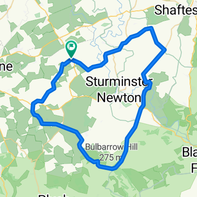
- 16.2 km
- 192 m
- 196 m
- Stalbridge, England, United Kingdom
Geocaching: Gillingham & Shaftesbury
A cycling route starting in Stalbridge, England, United Kingdom.
Overview
About this route
around some of the geocaches in the gillingham / shaftesbury area. cache locations approximate only.
- -:--
- Duration
- 62.4 km
- Distance
- 727 m
- Ascent
- 748 m
- Descent
- ---
- Avg. speed
- 263 m
- Max. altitude
created this 17 years ago
Route quality
Waytypes & surfaces along the route
Waytypes
Quiet road
27.5 km
(44 %)
Road
16.9 km
(27 %)
Undefined
18.1 km
(29 %)
Surfaces
Paved
12.5 km
(20 %)
Asphalt
12.5 km
(20 %)
Undefined
49.9 km
(80 %)
Route highlights
Points of interest along the route
Point of interest after 8.7 km
Fifehead Magdalen (Pumphouse)
Point of interest after 16.2 km
Sidetracked (Gillingham)
Point of interest after 20 km
Show me the cache
Point of interest after 23.2 km
Blackmore Vale View
Point of interest after 27.4 km
Compton Views
Point of interest after 31.7 km
Zig Zag Hill
Point of interest after 35.9 km
Ashmore
Continue with Bikemap
Use, edit, or download this cycling route
You would like to ride Geocaching: Gillingham & Shaftesbury or customize it for your own trip? Here is what you can do with this Bikemap route:
Free features
- Save this route as favorite or in collections
- Copy & plan your own version of this route
- Sync your route with Garmin or Wahoo
Premium features
Free trial for 3 days, or one-time payment. More about Bikemap Premium.
- Navigate this route on iOS & Android
- Export a GPX / KML file of this route
- Create your custom printout (try it for free)
- Download this route for offline navigation
Discover more Premium features.
Get Bikemap PremiumFrom our community
Other popular routes starting in Stalbridge
- Caundles
- Stalbridge to Stour Row and back
- 30.3 km
- 237 m
- 239 m
- Stalbridge, England, United Kingdom
- Marnhull - Gillingham, 21 miles
- 34.1 km
- 288 m
- 285 m
- Stalbridge, England, United Kingdom
- Okeford
- 52.3 km
- 448 m
- 467 m
- Stalbridge, England, United Kingdom
- Milborne Port, Henstridge, Stourton Caundle
- 19.9 km
- 217 m
- 201 m
- Stalbridge, England, United Kingdom
- Somerset
- 185.4 km
- 1,392 m
- 1,388 m
- Stalbridge, England, United Kingdom
- Landshire Lane
- 11 km
- 108 m
- 120 m
- Stalbridge, England, United Kingdom
- Geocaching: Gillingham & Shaftesbury
- 62.4 km
- 727 m
- 748 m
- Stalbridge, England, United Kingdom
Open it in the app


