

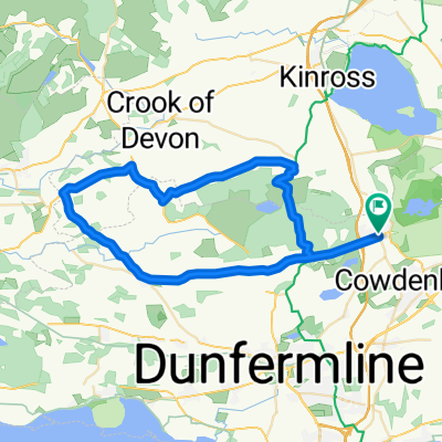
Cleish Hill twice > Gleneagles loop 59
A cycling route starting in Kelty, Scotland, United Kingdom.
Overview
About this route
A nice loop with good uphills and downhills exploring the boundaries of Kinross and Perthshire.
Start at edge of Kelty- shops and cafes nearby. Head West. Turn off to ascend and descend Cleish Hill- great view over Kinross and Loch Leven to Lomond Hills in East. Take flat roads to Kinross, Milnathort then East to Glenfarg turning (Beinn Inn). Follow narrow cleft through hills past Glenfarg then dropping down through trees (scenic & easy riding) past Beinn Inn to flat vale surrounding Bridge of Earn (shops here). Proceed along back roads past Strathallan, Forteviot and Dunning. All picturesque- foo options in Dunning. Back roads continue towards Gleneagles- avoiding Auchterarder. Climb over Glen Eagles- feels trickier than ascent on map indicates. Proceed rapidly through hills to Glendevon and yetts of Muckhart. Turn left at junction and follow flat-ish roads to Drum then Cleish and back over Cleish Hill in opposite direction (pretty tough). Alternative return to Kelty, without hills, is possible via Blairadam. - -:--
- Duration
- 95.8 km
- Distance
- 649 m
- Ascent
- 649 m
- Descent
- ---
- Avg. speed
- ---
- Max. altitude
Route quality
Waytypes & surfaces along the route
Waytypes
Quiet road
24 km
(25 %)
Road
6.7 km
(7 %)
Surfaces
Paved
51.8 km
(54 %)
Asphalt
50.8 km
(53 %)
Paved (undefined)
1 km
(1 %)
Undefined
44.1 km
(46 %)
Continue with Bikemap
Use, edit, or download this cycling route
You would like to ride Cleish Hill twice > Gleneagles loop 59 or customize it for your own trip? Here is what you can do with this Bikemap route:
Free features
- Save this route as favorite or in collections
- Copy & plan your own version of this route
- Split it into stages to create a multi-day tour
- Sync your route with Garmin or Wahoo
Premium features
Free trial for 3 days, or one-time payment. More about Bikemap Premium.
- Navigate this route on iOS & Android
- Export a GPX / KML file of this route
- Create your custom printout (try it for free)
- Download this route for offline navigation
Discover more Premium features.
Get Bikemap PremiumFrom our community
Other popular routes starting in Kelty
 KCC GP Cleish 10m 2023
- Distance
- 16 km
- Ascent
- 40 m
- Descent
- 46 m
- Location
- Kelty, Scotland, United Kingdom
 Kelty to St Andrews
- Distance
- 59.7 km
- Ascent
- 372 m
- Descent
- 481 m
- Location
- Kelty, Scotland, United Kingdom
 Stage 7
- Distance
- 67.8 km
- Ascent
- 549 m
- Descent
- 442 m
- Location
- Kelty, Scotland, United Kingdom
 Kelty Saline Powmill Cleish Kelty
- Distance
- 42.4 km
- Ascent
- 440 m
- Descent
- 440 m
- Location
- Kelty, Scotland, United Kingdom
 Cleish, Fife, Dunning 69
- Distance
- 110.9 km
- Ascent
- 1,167 m
- Descent
- 1,167 m
- Location
- Kelty, Scotland, United Kingdom
 Round The Lochs
- Distance
- 33.7 km
- Ascent
- 179 m
- Descent
- 179 m
- Location
- Kelty, Scotland, United Kingdom
 Kelty Saline Powmill Knockhill Kelty
- Distance
- 39.3 km
- Ascent
- 408 m
- Descent
- 408 m
- Location
- Kelty, Scotland, United Kingdom
 GVAP Rawhide Charity Cycle #2
- Distance
- 50.5 km
- Ascent
- 292 m
- Descent
- 333 m
- Location
- Kelty, Scotland, United Kingdom
Open it in the app