

VTT City to Kopstal
A cycling route starting in Luxembourg, District de Luxembourg, Luxembourg.
Overview
About this route
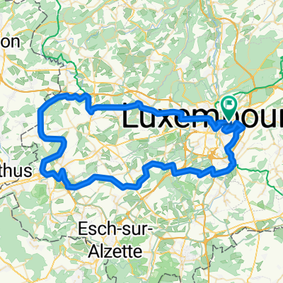
Start Place de lÉtoile. NW to Strassen via Rechenthal, NE to Kopstal & Direndall. Return via Steinsel Plateau & Bridel.
- -:--
- Duration
- 41.4 km
- Distance
- 849 m
- Ascent
- 849 m
- Descent
- ---
- Avg. speed
- ---
- Max. altitude

Continue with Bikemap
Use, edit, or download this cycling route
You would like to ride VTT City to Kopstal or customize it for your own trip? Here is what you can do with this Bikemap route:
Free features
- Save this route as favorite or in collections
- Copy & plan your own version of this route
- Sync your route with Garmin or Wahoo
Premium features
Free trial for 3 days, or one-time payment. More about Bikemap Premium.
- Navigate this route on iOS & Android
- Export a GPX / KML file of this route
- Create your custom printout (try it for free)
- Download this route for offline navigation
Discover more Premium features.
Get Bikemap PremiumFrom our community
Other popular routes starting in Luxembourg
 Route 10/05/25
- Distance
- 50.4 km
- Ascent
- 729 m
- Descent
- 751 m
- Location
- Luxembourg, District de Luxembourg, Luxembourg
 Playing in the Woods 13 December 08:00
- Distance
- 28.9 km
- Ascent
- 321 m
- Descent
- 324 m
- Location
- Luxembourg, District de Luxembourg, Luxembourg
 LUXEMBURG-LUXEMBUG
- Distance
- 66.2 km
- Ascent
- 523 m
- Descent
- 521 m
- Location
- Luxembourg, District de Luxembourg, Luxembourg
 9 Mai Tour
- Distance
- 72.5 km
- Ascent
- 837 m
- Descent
- 835 m
- Location
- Luxembourg, District de Luxembourg, Luxembourg
 J1A RC2 MIP2018
- Distance
- 50.2 km
- Ascent
- 119 m
- Descent
- 226 m
- Location
- Luxembourg, District de Luxembourg, Luxembourg
 PC02 d'Echternach
- Distance
- 49.1 km
- Ascent
- 395 m
- Descent
- 550 m
- Location
- Luxembourg, District de Luxembourg, Luxembourg
 VTT City to Kopstal
- Distance
- 41.4 km
- Ascent
- 849 m
- Descent
- 849 m
- Location
- Luxembourg, District de Luxembourg, Luxembourg
 Bambesch - Biergerkräiz
- Distance
- 13.8 km
- Ascent
- 929 m
- Descent
- 934 m
- Location
- Luxembourg, District de Luxembourg, Luxembourg
Open it in the app