

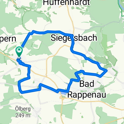
Siegelsbach KR7 Fünfmühlental Römersee
A cycling route starting in Siegelsbach, Baden-Wurttemberg, Germany.
Overview
About this route
Start point: Penny parking lot 74936 Siegelsbach, Hauptstraße / Rödelweg
- -:--
- Duration
- 6.6 km
- Distance
- 71 m
- Ascent
- 66 m
- Descent
- ---
- Avg. speed
- ---
- Max. altitude

Route quality
Waytypes & surfaces along the route
Waytypes
Track
4.4 km
(66 %)
Access road
0.7 km
(11 %)
Surfaces
Paved
4.1 km
(62 %)
Unpaved
2.4 km
(37 %)
Asphalt
4.1 km
(62 %)
Gravel
2.4 km
(37 %)
Undefined
0.1 km
(1 %)
Continue with Bikemap
Use, edit, or download this cycling route
You would like to ride Siegelsbach KR7 Fünfmühlental Römersee or customize it for your own trip? Here is what you can do with this Bikemap route:
Free features
- Save this route as favorite or in collections
- Copy & plan your own version of this route
- Sync your route with Garmin or Wahoo
Premium features
Free trial for 3 days, or one-time payment. More about Bikemap Premium.
- Navigate this route on iOS & Android
- Export a GPX / KML file of this route
- Create your custom printout (try it for free)
- Download this route for offline navigation
Discover more Premium features.
Get Bikemap PremiumFrom our community
Other popular routes starting in Siegelsbach
 Neckarsulm - Biberach - Treschklingen - Obergimpern
- Distance
- 45.9 km
- Ascent
- 288 m
- Descent
- 288 m
- Location
- Siegelsbach, Baden-Wurttemberg, Germany
 Neckargemünd
- Distance
- 96.4 km
- Ascent
- 392 m
- Descent
- 395 m
- Location
- Siegelsbach, Baden-Wurttemberg, Germany
 Henkert
- Distance
- 10.6 km
- Ascent
- 211 m
- Descent
- 211 m
- Location
- Siegelsbach, Baden-Wurttemberg, Germany
 Waldschänke Obereisesheim
- Distance
- 12.7 km
- Ascent
- 91 m
- Descent
- 168 m
- Location
- Siegelsbach, Baden-Wurttemberg, Germany
 Trainingsrunde Kohlhof
- Distance
- 10.9 km
- Ascent
- 82 m
- Descent
- 80 m
- Location
- Siegelsbach, Baden-Wurttemberg, Germany
 OBG-BS-BR-SIGB-OBG
- Distance
- 20 km
- Ascent
- 162 m
- Descent
- 159 m
- Location
- Siegelsbach, Baden-Wurttemberg, Germany
 Bad Rappenau.gpx
- Distance
- 23.4 km
- Ascent
- 162 m
- Descent
- 170 m
- Location
- Siegelsbach, Baden-Wurttemberg, Germany
 Salzbergwerk
- Distance
- 40 km
- Ascent
- 408 m
- Descent
- 409 m
- Location
- Siegelsbach, Baden-Wurttemberg, Germany
Open it in the app