Medzilaborce - Komańcza - Rzepedź - Turzańsk - Szczawne
A cycling route starting in Medzilaborce, Prešov Region, Slovakia.
Overview
About this route
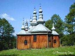
Planned route with a tour of wooden churches (Szlak ikon doliny Oslawy)
- -:--
- Duration
- 40 km
- Distance
- 482 m
- Ascent
- 407 m
- Descent
- ---
- Avg. speed
- ---
- Max. altitude
Route highlights
Points of interest along the route

Point of interest after 16 km
foto: J. Schneider

Point of interest after 19.8 km
foto: J. Schneider

Point of interest after 20.2 km
foto: J. Schneider

Point of interest after 32.9 km
foto: P. Szechyński

Point of interest after 36.4 km
foto: P. Szechński

Point of interest after 38.5 km
foto: P. Szechyński
Continue with Bikemap
Use, edit, or download this cycling route
You would like to ride Medzilaborce - Komańcza - Rzepedź - Turzańsk - Szczawne or customize it for your own trip? Here is what you can do with this Bikemap route:
Free features
- Save this route as favorite or in collections
- Copy & plan your own version of this route
- Sync your route with Garmin or Wahoo
Premium features
Free trial for 3 days, or one-time payment. More about Bikemap Premium.
- Navigate this route on iOS & Android
- Export a GPX / KML file of this route
- Create your custom printout (try it for free)
- Download this route for offline navigation
Discover more Premium features.
Get Bikemap PremiumFrom our community
Other popular routes starting in Medzilaborce
 Cyklotrek Jasielko - Haburské rašeliniská
- Distance
- 33.7 km
- Ascent
- 540 m
- Descent
- 532 m
- Location
- Medzilaborce, Prešov Region, Slovakia
 ML - Výrava - Zbojné - Jabloň - Zubné - Svetlice - ML
- Distance
- 74.5 km
- Ascent
- 619 m
- Descent
- 619 m
- Location
- Medzilaborce, Prešov Region, Slovakia
 Cyklotrek Mikov
- Distance
- 64 km
- Ascent
- 739 m
- Descent
- 749 m
- Location
- Medzilaborce, Prešov Region, Slovakia
 ML - Danova - Pasika 844 m - Kalinov - ML
- Distance
- 28.8 km
- Ascent
- 578 m
- Descent
- 578 m
- Location
- Medzilaborce, Prešov Region, Slovakia
 Cyklotrek Haburské rašelinisko
- Distance
- 52.3 km
- Ascent
- 542 m
- Descent
- 538 m
- Location
- Medzilaborce, Prešov Region, Slovakia
 Medzilaborce-Komancza-Duszatyn-Smolnik-Lupkowsky tunel
- Distance
- 57.3 km
- Ascent
- 781 m
- Descent
- 585 m
- Location
- Medzilaborce, Prešov Region, Slovakia
 ML - Smolnik - Duszatyn - Komańcza - ML
- Distance
- 63 km
- Ascent
- 761 m
- Descent
- 762 m
- Location
- Medzilaborce, Prešov Region, Slovakia
 ML - Radoszyce - Smolnik - Nowy Lupkow - ML
- Distance
- 61 km
- Ascent
- 818 m
- Descent
- 818 m
- Location
- Medzilaborce, Prešov Region, Slovakia
Open it in the app


