

Rappbodetalsperre
A cycling route starting in Wernigerode, Saxony-Anhalt, Germany.
Overview
About this route
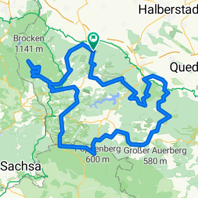
Einmal rund um die Rappbodetalsperre.
Von Wernigerode aus über Rübeland und dann immer an der Talsperre entlang. Zurück geht es über Elbingerode und dann durch das Zillerbachtal nach Wernigerode. Reizvolle Runde mit vielen kleineren Vorsperren in landschaftlich perfekter Umgebung für ein Mountainbike.
Variationen sind nach eigenem Bedürfnis natürlich immer möglich.
- -:--
- Duration
- 54.7 km
- Distance
- 768 m
- Ascent
- 768 m
- Descent
- ---
- Avg. speed
- ---
- Max. altitude
Continue with Bikemap
Use, edit, or download this cycling route
You would like to ride Rappbodetalsperre or customize it for your own trip? Here is what you can do with this Bikemap route:
Free features
- Save this route as favorite or in collections
- Copy & plan your own version of this route
- Sync your route with Garmin or Wahoo
Premium features
Free trial for 3 days, or one-time payment. More about Bikemap Premium.
- Navigate this route on iOS & Android
- Export a GPX / KML file of this route
- Create your custom printout (try it for free)
- Download this route for offline navigation
Discover more Premium features.
Get Bikemap PremiumFrom our community
Other popular routes starting in Wernigerode
 Zanthiersteintour
- Distance
- 22 km
- Ascent
- 447 m
- Descent
- 444 m
- Location
- Wernigerode, Saxony-Anhalt, Germany
 Wurmberg
- Distance
- 57.2 km
- Ascent
- 1,056 m
- Descent
- 916 m
- Location
- Wernigerode, Saxony-Anhalt, Germany
 Wernigerode: Brocken rauf und runter
- Distance
- 57.5 km
- Ascent
- 1,079 m
- Descent
- 1,078 m
- Location
- Wernigerode, Saxony-Anhalt, Germany
 Brockentour
- Distance
- 39.9 km
- Ascent
- 1,133 m
- Descent
- 977 m
- Location
- Wernigerode, Saxony-Anhalt, Germany
 Wernigerode - Brocken - Bad Harzburg - Wernigerode
- Distance
- 91.4 km
- Ascent
- 1,313 m
- Descent
- 1,313 m
- Location
- Wernigerode, Saxony-Anhalt, Germany
 Große Dammstraße 32, Wernigerode nach Große Dammstraße 32, Wernigerode
- Distance
- 16.5 km
- Ascent
- 16 m
- Descent
- 7 m
- Location
- Wernigerode, Saxony-Anhalt, Germany
 Wernigerode -> Walkenried -> Thale Hbf.
- Distance
- 94.4 km
- Ascent
- 1,169 m
- Descent
- 1,017 m
- Location
- Wernigerode, Saxony-Anhalt, Germany
 Brockenrunde
- Distance
- 153 km
- Ascent
- 2,210 m
- Descent
- 2,116 m
- Location
- Wernigerode, Saxony-Anhalt, Germany
Open it in the app