

Kartouzka Berg
A cycling route starting in Velký Týnec, Olomoucký kraj, Czechia.
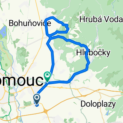
Overview
About this route
ěééáí.+.Okruh
- -:--
- Duration
- 34.9 km
- Distance
- 425 m
- Ascent
- 397 m
- Descent
- ---
- Avg. speed
- 431 m
- Max. altitude
Route quality
Waytypes & surfaces along the route
Waytypes
Road
21.3 km
(61 %)
Track
5.2 km
(15 %)
Surfaces
Paved
13.2 km
(38 %)
Unpaved
2.4 km
(7 %)
Asphalt
12.9 km
(37 %)
Gravel
1.7 km
(5 %)
Continue with Bikemap
Use, edit, or download this cycling route
You would like to ride Kartouzka Berg or customize it for your own trip? Here is what you can do with this Bikemap route:
Free features
- Save this route as favorite or in collections
- Copy & plan your own version of this route
- Sync your route with Garmin or Wahoo
Premium features
Free trial for 3 days, or one-time payment. More about Bikemap Premium.
- Navigate this route on iOS & Android
- Export a GPX / KML file of this route
- Create your custom printout (try it for free)
- Download this route for offline navigation
Discover more Premium features.
Get Bikemap PremiumFrom our community
Other popular routes starting in Velký Týnec
 Olomoucké cyklobuznění 2014
- Distance
- 78.8 km
- Ascent
- 766 m
- Descent
- 795 m
- Location
- Velký Týnec, Olomoucký kraj, Czechia
 Tour de Praded
- Distance
- 162.5 km
- Ascent
- 1,416 m
- Descent
- 1,416 m
- Location
- Velký Týnec, Olomoucký kraj, Czechia
 Kartouzka Berg
- Distance
- 34.9 km
- Ascent
- 425 m
- Descent
- 397 m
- Location
- Velký Týnec, Olomoucký kraj, Czechia
 Holice - Velká Bystřice - Posluchov a zpět
- Distance
- 33.2 km
- Ascent
- 202 m
- Descent
- 202 m
- Location
- Velký Týnec, Olomoucký kraj, Czechia
 Trasa Vsisko-Sv.Kopeček
- Distance
- 29 km
- Ascent
- 239 m
- Descent
- 238 m
- Location
- Velký Týnec, Olomoucký kraj, Czechia
 Výlet s "arabem"
- Distance
- 46 km
- Ascent
- 310 m
- Descent
- 310 m
- Location
- Velký Týnec, Olomoucký kraj, Czechia
 Výkleky
- Distance
- 42.4 km
- Ascent
- 299 m
- Descent
- 299 m
- Location
- Velký Týnec, Olomoucký kraj, Czechia
 závod hradisko
- Distance
- 14.1 km
- Ascent
- 305 m
- Descent
- 303 m
- Location
- Velký Týnec, Olomoucký kraj, Czechia
Open it in the app