
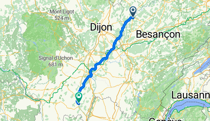
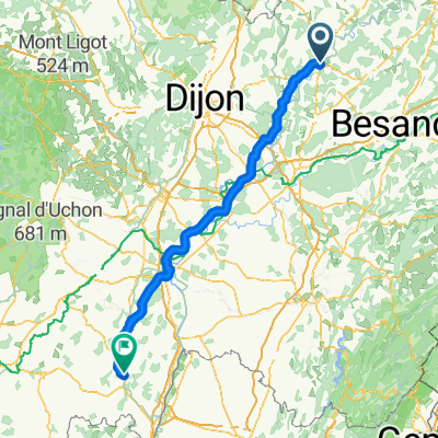
Jakobsweg Etappe 3 Gray - Cluny CLONED FROM ROUTE 525057
A cycling route starting in Gray, Bourgogne-Franche-Comté, France.
Overview
About this route
Entlang der Saône und des Doubs bis Chalôn, von Saint-Jean-de-Losne auf dem Jakobsweg bis Cluny.
Der erste Teil ist meist sehr flach auf verkehrsarmen Strassen durch die Wiesen und Felder im Flusstal der Saône. Die einzige nennenswerte Steigung ist kurz vor Cluny: Da wird es etwas steiler - am Ende bis zu 17%.
Einfacher ist es der voie verte, einer still gelegten Bahntrasse, ab St Genoux-le-National bis Cluny zu folgen. Diese Variante ist deutlich flacher. Die voie verte ist gut beschildert.
Zum Großteil geht es nach Gray über verkehrsarme Strassen. Nur das Nadelöhr über die Brücken der Saône und die der Autobahn in Chalon sollte man, wenn möglich nicht gerade zur Berufsverkehrszeit passieren.
Gutes "Plat du Jour" (Tagesmenü) zum Mittagessen auf dem Weg.
- -:--
- Duration
- 162.8 km
- Distance
- 394 m
- Ascent
- 369 m
- Descent
- ---
- Avg. speed
- ---
- Max. altitude
Route quality
Waytypes & surfaces along the route
Waytypes
Quiet road
24.4 km
(15 %)
Track
13 km
(8 %)
Surfaces
Paved
35.8 km
(22 %)
Unpaved
3.3 km
(2 %)
Asphalt
35.8 km
(22 %)
Ground
3.3 km
(2 %)
Undefined
123.7 km
(76 %)
Continue with Bikemap
Use, edit, or download this cycling route
You would like to ride Jakobsweg Etappe 3 Gray - Cluny CLONED FROM ROUTE 525057 or customize it for your own trip? Here is what you can do with this Bikemap route:
Free features
- Save this route as favorite or in collections
- Copy & plan your own version of this route
- Split it into stages to create a multi-day tour
- Sync your route with Garmin or Wahoo
Premium features
Free trial for 3 days, or one-time payment. More about Bikemap Premium.
- Navigate this route on iOS & Android
- Export a GPX / KML file of this route
- Create your custom printout (try it for free)
- Download this route for offline navigation
Discover more Premium features.
Get Bikemap PremiumFrom our community
Other popular routes starting in Gray
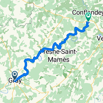
 21 - GRAY à ESSERTENNE-ET-CECEY
- Distance
- 20 km
- Ascent
- 36 m
- Descent
- 44 m
- Location
- Gray, Bourgogne-Franche-Comté, France
 De Gray à Port-sur-Saône
- Distance
- 66.5 km
- Ascent
- 341 m
- Descent
- 316 m
- Location
- Gray, Bourgogne-Franche-Comté, France
 Veloroute du Soleil: dag 9
- Distance
- 98.3 km
- Ascent
- 229 m
- Descent
- 195 m
- Location
- Gray, Bourgogne-Franche-Comté, France
 Jakobsweg Etappe 3 Gray - Cluny CLONED FROM ROUTE 525057
- Distance
- 162.8 km
- Ascent
- 394 m
- Descent
- 369 m
- Location
- Gray, Bourgogne-Franche-Comté, France
 Donderdag Dag 7 22-07-2021 Gray -Chagny Camping Du Paquier Fane
- Distance
- 107.9 km
- Ascent
- 249 m
- Descent
- 230 m
- Location
- Gray, Bourgogne-Franche-Comté, France
 E113 Gray - Saint-Usage
- Distance
- 64.5 km
- Ascent
- 62 m
- Descent
- 72 m
- Location
- Gray, Bourgogne-Franche-Comté, France
 Tag 12 - KobDij - Gray bis Dijon
- Distance
- 72.9 km
- Ascent
- 394 m
- Descent
- 336 m
- Location
- Gray, Bourgogne-Franche-Comté, France
 Lyon - Basel, 5. Etappe
- Distance
- 67.6 km
- Ascent
- 238 m
- Descent
- 220 m
- Location
- Gray, Bourgogne-Franche-Comté, France
Open it in the app