

himmelreich - bartholomä - rosenstein
A cycling route starting in Heubach, Baden-Wurttemberg, Germany.
Overview
About this route
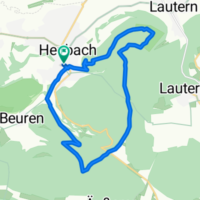
Heubach - Beuren - Himmelreich - Bargauer Kreuz - Bartholomä - Lauterburg - Rosenstein - Heubach
- -:--
- Duration
- 19.7 km
- Distance
- 431 m
- Ascent
- 431 m
- Descent
- ---
- Avg. speed
- ---
- Max. altitude
Route quality
Waytypes & surfaces along the route
Waytypes
Track
11.6 km
(59 %)
Quiet road
7.3 km
(37 %)
Surfaces
Paved
6.7 km
(34 %)
Unpaved
10 km
(51 %)
Gravel
10 km
(51 %)
Asphalt
6.7 km
(34 %)
Undefined
2.9 km
(15 %)
Route highlights
Points of interest along the route
Point of interest after 11.9 km
Gasthof Moser
Point of interest after 13.2 km
Bildstöckle
Continue with Bikemap
Use, edit, or download this cycling route
You would like to ride himmelreich - bartholomä - rosenstein or customize it for your own trip? Here is what you can do with this Bikemap route:
Free features
- Save this route as favorite or in collections
- Copy & plan your own version of this route
- Sync your route with Garmin or Wahoo
Premium features
Free trial for 3 days, or one-time payment. More about Bikemap Premium.
- Navigate this route on iOS & Android
- Export a GPX / KML file of this route
- Create your custom printout (try it for free)
- Download this route for offline navigation
Discover more Premium features.
Get Bikemap PremiumFrom our community
Other popular routes starting in Heubach
 himmelreich - bartholomä - rosenstein
- Distance
- 19.7 km
- Ascent
- 431 m
- Descent
- 431 m
- Location
- Heubach, Baden-Wurttemberg, Germany
 rosenstein-tauchenweiler-himmelreich
- Distance
- 30.5 km
- Ascent
- 558 m
- Descent
- 560 m
- Location
- Heubach, Baden-Wurttemberg, Germany
 09_teufelsklinge
- Distance
- 12.4 km
- Ascent
- 464 m
- Descent
- 464 m
- Location
- Heubach, Baden-Wurttemberg, Germany
 Rosenstein,Kaltes Feld,Drei Kaiserberge
- Distance
- 35.8 km
- Ascent
- 511 m
- Descent
- 745 m
- Location
- Heubach, Baden-Wurttemberg, Germany
 tauchenweiler 40
- Distance
- 39.4 km
- Ascent
- 612 m
- Descent
- 612 m
- Location
- Heubach, Baden-Wurttemberg, Germany
 Heubach H-Gröningen Abtsgmünd Heubach
- Distance
- 50.7 km
- Ascent
- 570 m
- Descent
- 570 m
- Location
- Heubach, Baden-Wurttemberg, Germany
 Route in Schwäbisch Gmünd
- Distance
- 7.7 km
- Ascent
- 44 m
- Descent
- 142 m
- Location
- Heubach, Baden-Wurttemberg, Germany
 Rica Route 1
- Distance
- 97.4 km
- Ascent
- 944 m
- Descent
- 992 m
- Location
- Heubach, Baden-Wurttemberg, Germany
Open it in the app