

Gordon Bennett 1904
A cycling route starting in Dehrn, Hesse, Germany.
Overview
About this route
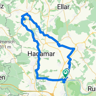
Randonneurs - Variante der Strecke vom Gordon bennett Cup 1904 - Internationales Automobilrennen mit Start und Ziel an der Saalburg /Homburg
- -:--
- Duration
- 155.9 km
- Distance
- 1,502 m
- Ascent
- 1,486 m
- Descent
- ---
- Avg. speed
- ---
- Max. altitude
Route quality
Waytypes & surfaces along the route
Waytypes
Quiet road
20.3 km
(13 %)
Road
18.7 km
(12 %)
Surfaces
Paved
101.4 km
(65 %)
Unpaved
14 km
(9 %)
Asphalt
96.7 km
(62 %)
Gravel
7.8 km
(5 %)
Continue with Bikemap
Use, edit, or download this cycling route
You would like to ride Gordon Bennett 1904 or customize it for your own trip? Here is what you can do with this Bikemap route:
Free features
- Save this route as favorite or in collections
- Copy & plan your own version of this route
- Split it into stages to create a multi-day tour
- Sync your route with Garmin or Wahoo
Premium features
Free trial for 3 days, or one-time payment. More about Bikemap Premium.
- Navigate this route on iOS & Android
- Export a GPX / KML file of this route
- Create your custom printout (try it for free)
- Download this route for offline navigation
Discover more Premium features.
Get Bikemap PremiumFrom our community
Other popular routes starting in Dehrn
 Mundipharma-Aartal-Zollhaus-Erbach-Weiltal-Freienfels-Home
- Distance
- 89.8 km
- Ascent
- 842 m
- Descent
- 809 m
- Location
- Dehrn, Hesse, Germany
 limburg-loreley-limburg
- Distance
- 147.8 km
- Ascent
- 965 m
- Descent
- 954 m
- Location
- Dehrn, Hesse, Germany
 Steedener Weg 14, Runkel nach Limburg, Limburg an der Lahn
- Distance
- 5.1 km
- Ascent
- 1 m
- Descent
- 0 m
- Location
- Dehrn, Hesse, Germany
 Mundi-Arfurt-Schupbach
- Distance
- 34.5 km
- Ascent
- 397 m
- Descent
- 357 m
- Location
- Dehrn, Hesse, Germany
 Fahlerstraße nach Fahlerstraße
- Distance
- 32.1 km
- Ascent
- 344 m
- Descent
- 395 m
- Location
- Dehrn, Hesse, Germany
 Leichte Fahrt
- Distance
- 35.5 km
- Ascent
- 259 m
- Descent
- 259 m
- Location
- Dehrn, Hesse, Germany
 MP-Wiesensee-Krombachtal-Seeweiher-MP
- Distance
- 95.9 km
- Ascent
- 954 m
- Descent
- 954 m
- Location
- Dehrn, Hesse, Germany
 Emsbach-Wörsbach-Runde
- Distance
- 54.1 km
- Ascent
- 422 m
- Descent
- 425 m
- Location
- Dehrn, Hesse, Germany
Open it in the app