

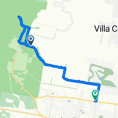
sala-siambon-portezuelo
A cycling route starting in Yerba Buena, Tucumán Province, Argentina.
Overview
About this route
- 5 h 16 min
- Duration
- 50.3 km
- Distance
- 1,541 m
- Ascent
- 1,539 m
- Descent
- 9.5 km/h
- Avg. speed
- ---
- Max. altitude

Route quality
Waytypes & surfaces along the route
Waytypes
Path
12.6 km
(25 %)
Quiet road
3.5 km
(7 %)
Surfaces
Paved
28.7 km
(57 %)
Unpaved
2 km
(4 %)
Paved (undefined)
25.6 km
(51 %)
Asphalt
3 km
(6 %)
Continue with Bikemap
Use, edit, or download this cycling route
You would like to ride sala-siambon-portezuelo or customize it for your own trip? Here is what you can do with this Bikemap route:
Free features
- Save this route as favorite or in collections
- Copy & plan your own version of this route
- Sync your route with Garmin or Wahoo
Premium features
Free trial for 3 days, or one-time payment. More about Bikemap Premium.
- Navigate this route on iOS & Android
- Export a GPX / KML file of this route
- Create your custom printout (try it for free)
- Download this route for offline navigation
Discover more Premium features.
Get Bikemap PremiumFrom our community
Other popular routes starting in Yerba Buena
 De Tucumán a Avenida Juan Domingo Perón 1321, Yerba Buena
- Distance
- 10.4 km
- Ascent
- 62 m
- Descent
- 246 m
- Location
- Yerba Buena, Tucumán Province, Argentina
 Trasmontaña 2011
- Distance
- 43.1 km
- Ascent
- 1,076 m
- Descent
- 1,179 m
- Location
- Yerba Buena, Tucumán Province, Argentina
 Trasmontaña Tucumán 2017
- Distance
- 43.2 km
- Ascent
- 1,109 m
- Descent
- 1,139 m
- Location
- Yerba Buena, Tucumán Province, Argentina
 Vuelta:subida San Javier - bajada por Villa Nougues
- Distance
- 41.7 km
- Ascent
- 1,097 m
- Descent
- 1,114 m
- Location
- Yerba Buena, Tucumán Province, Argentina
 RP339, Yerba Buena a Paso de los Andes, Municipalidad de San Miguel De Tucuman
- Distance
- 10.3 km
- Ascent
- 13 m
- Descent
- 124 m
- Location
- Yerba Buena, Tucumán Province, Argentina
 transmontaña 2011
- Distance
- 43 km
- Ascent
- 1,397 m
- Descent
- 1,501 m
- Location
- Yerba Buena, Tucumán Province, Argentina
 trasmontaña 2011
- Distance
- 43.5 km
- Ascent
- 1,070 m
- Descent
- 1,182 m
- Location
- Yerba Buena, Tucumán Province, Argentina
 Trepada a San Javier desde rotonda pié del cerro.
- Distance
- 9 km
- Ascent
- 921 m
- Descent
- 179 m
- Location
- Yerba Buena, Tucumán Province, Argentina
Open it in the app