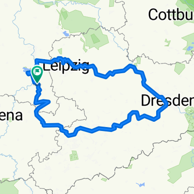
Weißenfels-Bad Kösen-Rehehausen-Apolda
A cycling route starting in Weißenfels, Saxony-Anhalt, Germany.
Overview
About this route
- -:--
- Duration
- 60.3 km
- Distance
- 352 m
- Ascent
- 271 m
- Descent
- ---
- Avg. speed
- ---
- Avg. speed
Route quality
Waytypes & surfaces along the route
Waytypes
Quiet road
21.1 km
(35 %)
Path
9.4 km
(16 %)
Surfaces
Paved
47.4 km
(78 %)
Unpaved
3.2 km
(5 %)
Asphalt
43.9 km
(73 %)
Ground
2.1 km
(4 %)
Route highlights
Points of interest along the route
Point of interest after 16.1 km
Umleitung wegen Uferarbeiten über Hausberg
Point of interest after 23.7 km
durch den Weinberg
Continue with Bikemap
Use, edit, or download this cycling route
You would like to ride Weißenfels-Bad Kösen-Rehehausen-Apolda or customize it for your own trip? Here is what you can do with this Bikemap route:
Free features
- Save this route as favorite or in collections
- Copy & plan your own version of this route
- Sync your route with Garmin or Wahoo
Premium features
Free trial for 3 days, or one-time payment. More about Bikemap Premium.
- Navigate this route on iOS & Android
- Export a GPX / KML file of this route
- Create your custom printout (try it for free)
- Download this route for offline navigation
Discover more Premium features.
Get Bikemap PremiumFrom our community
Other popular routes starting in Weißenfels
- Südfeldsee und Saaleradweg
- Distance
- 28.9 km
- Ascent
- 167 m
- Descent
- 165 m
- Location
- Weißenfels, Saxony-Anhalt, Germany
- Runde2025
- Distance
- 487.1 km
- Ascent
- 3,574 m
- Descent
- 3,573 m
- Location
- Weißenfels, Saxony-Anhalt, Germany
- 12 Apostelbrücke
- Distance
- 119.4 km
- Ascent
- 360 m
- Descent
- 360 m
- Location
- Weißenfels, Saxony-Anhalt, Germany
- Zeitzer Gärten, Weißenfels nach Karl-Marx-Siedlung 49, Weißenfels
- Distance
- 8.5 km
- Ascent
- 84 m
- Descent
- 87 m
- Location
- Weißenfels, Saxony-Anhalt, Germany
- Weißenfels-Leipzig
- Distance
- 51.2 km
- Ascent
- 149 m
- Descent
- 104 m
- Location
- Weißenfels, Saxony-Anhalt, Germany
- D11 cheat Weissenfels bis Grafenhainichen
- Distance
- 102.7 km
- Ascent
- 130 m
- Descent
- 136 m
- Location
- Weißenfels, Saxony-Anhalt, Germany
- WSF 002: Weißenfelsrunde 2
- Distance
- 93.3 km
- Ascent
- 347 m
- Descent
- 347 m
- Location
- Weißenfels, Saxony-Anhalt, Germany
- SRW_Etappe7
- Distance
- 68.8 km
- Ascent
- 135 m
- Descent
- 143 m
- Location
- Weißenfels, Saxony-Anhalt, Germany