

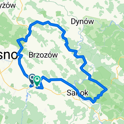
II dzień Przełomy Wisłoka:skarby przyrody i krajobrazu
A cycling route starting in Besko, Subcarpathian Voivodeship, Poland.
Overview
About this route
II dzień Przełomy Wisłoka:skarby przyrody i krajobrazu
- -:--
- Duration
- 91.3 km
- Distance
- 302 m
- Ascent
- 402 m
- Descent
- ---
- Avg. speed
- ---
- Max. altitude

Route quality
Waytypes & surfaces along the route
Waytypes
Busy road
38.5 km
(42 %)
Quiet road
24.3 km
(27 %)
Surfaces
Paved
75.3 km
(82 %)
Unpaved
3.8 km
(4 %)
Asphalt
73.5 km
(81 %)
Pebblestone
2.8 km
(3 %)
Continue with Bikemap
Use, edit, or download this cycling route
You would like to ride II dzień Przełomy Wisłoka:skarby przyrody i krajobrazu or customize it for your own trip? Here is what you can do with this Bikemap route:
Free features
- Save this route as favorite or in collections
- Copy & plan your own version of this route
- Split it into stages to create a multi-day tour
- Sync your route with Garmin or Wahoo
Premium features
Free trial for 3 days, or one-time payment. More about Bikemap Premium.
- Navigate this route on iOS & Android
- Export a GPX / KML file of this route
- Create your custom printout (try it for free)
- Download this route for offline navigation
Discover more Premium features.
Get Bikemap PremiumFrom our community
Other popular routes starting in Besko
 Magurski Park Narodowy
- Distance
- 141.2 km
- Ascent
- 1,065 m
- Descent
- 1,065 m
- Location
- Besko, Subcarpathian Voivodeship, Poland
 Besko - Sanok - Bukowsko
- Distance
- 29.3 km
- Ascent
- 164 m
- Descent
- 60 m
- Location
- Besko, Subcarpathian Voivodeship, Poland
 Besko - Iskrzynia - Domaradz - Brzozów - Turze Pole - Wzdów - Besko
- Distance
- 64.4 km
- Ascent
- 391 m
- Descent
- 389 m
- Location
- Besko, Subcarpathian Voivodeship, Poland
 Besko - Bukowsko - Szczawne Kulaszne - Zagórz - Sanok (pętla)
- Distance
- 79.7 km
- Ascent
- 570 m
- Descent
- 570 m
- Location
- Besko, Subcarpathian Voivodeship, Poland
 Dróżka na około
- Distance
- 137.2 km
- Ascent
- 945 m
- Descent
- 950 m
- Location
- Besko, Subcarpathian Voivodeship, Poland
 Pętla strukturalna
- Distance
- 88.7 km
- Ascent
- 557 m
- Descent
- 556 m
- Location
- Besko, Subcarpathian Voivodeship, Poland
 II dzień Przełomy Wisłoka:skarby przyrody i krajobrazu
- Distance
- 91.3 km
- Ascent
- 302 m
- Descent
- 402 m
- Location
- Besko, Subcarpathian Voivodeship, Poland
 Besko - Bukowsko - Komańcza - Jaśliska - Besko
- Distance
- 96.9 km
- Ascent
- 636 m
- Descent
- 636 m
- Location
- Besko, Subcarpathian Voivodeship, Poland
Open it in the app