

2010 Thüringen, Ostbayern, Böhmen Tag 4
A cycling route starting in Bad Steben, Bavaria, Germany.
Overview
About this route
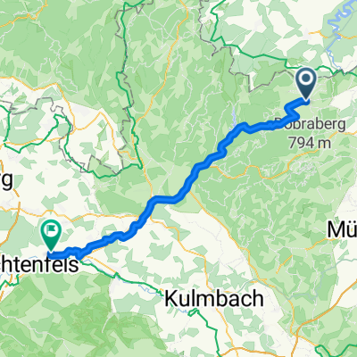
The fourth day of the tour. Today we ride only in the morning and then head back home from our starting point, Hirschberg Juchöh. After a short, swift descent, we cross the Saale in Spamberg and the state border between Bavaria and Thuringia. In Hirschberg, there is still a massive ramp with a 20% gradient to overcome. After that, it's just a moderate incline until Juchöh, and it's done.
- -:--
- Duration
- 25.9 km
- Distance
- 486 m
- Ascent
- 457 m
- Descent
- ---
- Avg. speed
- ---
- Max. altitude
Route quality
Waytypes & surfaces along the route
Waytypes
Road
15.3 km
(59 %)
Track
1.8 km
(7 %)
Surfaces
Paved
15.3 km
(59 %)
Unpaved
0.3 km
(1 %)
Asphalt
12.7 km
(49 %)
Paved (undefined)
2.6 km
(10 %)
Continue with Bikemap
Use, edit, or download this cycling route
You would like to ride 2010 Thüringen, Ostbayern, Böhmen Tag 4 or customize it for your own trip? Here is what you can do with this Bikemap route:
Free features
- Save this route as favorite or in collections
- Copy & plan your own version of this route
- Sync your route with Garmin or Wahoo
Premium features
Free trial for 3 days, or one-time payment. More about Bikemap Premium.
- Navigate this route on iOS & Android
- Export a GPX / KML file of this route
- Create your custom printout (try it for free)
- Download this route for offline navigation
Discover more Premium features.
Get Bikemap PremiumFrom our community
Other popular routes starting in Bad Steben
 Blankenstein - Redwitz an der Rodach
- Distance
- 56.6 km
- Ascent
- 450 m
- Descent
- 758 m
- Location
- Bad Steben, Bavaria, Germany
 005 komo-bad-steben-leipzig_export
- Distance
- 156.3 km
- Ascent
- 519 m
- Descent
- 976 m
- Location
- Bad Steben, Bavaria, Germany
 04 Bad Steben-Kronach
- Distance
- 42.2 km
- Ascent
- 532 m
- Descent
- 779 m
- Location
- Bad Steben, Bavaria, Germany
 2010 Thüringen, Ostbayern, Böhmen Tag 4
- Distance
- 25.9 km
- Ascent
- 486 m
- Descent
- 457 m
- Location
- Bad Steben, Bavaria, Germany
 Frankenrundfahrt
- Distance
- 107.3 km
- Ascent
- 1,650 m
- Descent
- 1,677 m
- Location
- Bad Steben, Bavaria, Germany
 Tour_zur_Kur_HO_12
- Distance
- 34.5 km
- Ascent
- 467 m
- Descent
- 465 m
- Location
- Bad Steben, Bavaria, Germany
 Steinige Tour (Schleife 1)
- Distance
- 20.5 km
- Ascent
- 291 m
- Descent
- 297 m
- Location
- Bad Steben, Bavaria, Germany
 Bad Steben - Mörlareuth
- Distance
- 25.4 km
- Ascent
- 504 m
- Descent
- 526 m
- Location
- Bad Steben, Bavaria, Germany
Open it in the app