
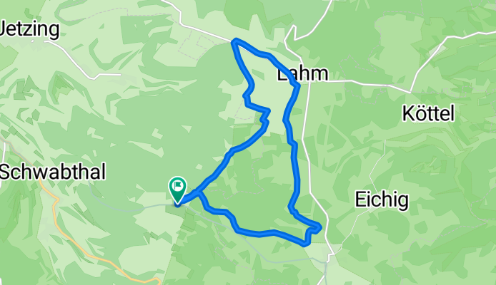
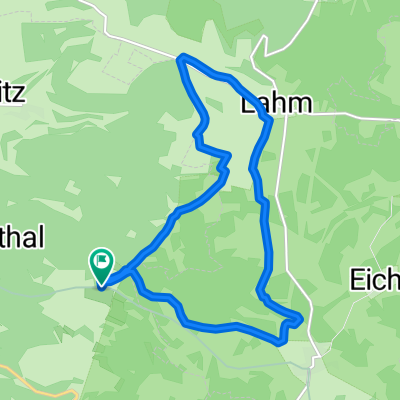
Lahme(r) Runde bei Wattendorf Rothmannsthal
A cycling route starting in Wattendorf, Bavaria, Germany.
Overview
About this route
From Hohlen Stein towards Lahm and around Lahm further towards Rothmannstal, back to the starting point
- -:--
- Duration
- 11.6 km
- Distance
- 209 m
- Ascent
- 208 m
- Descent
- ---
- Avg. speed
- ---
- Max. altitude

Continue with Bikemap
Use, edit, or download this cycling route
You would like to ride Lahme(r) Runde bei Wattendorf Rothmannsthal or customize it for your own trip? Here is what you can do with this Bikemap route:
Free features
- Save this route as favorite or in collections
- Copy & plan your own version of this route
- Sync your route with Garmin or Wahoo
Premium features
Free trial for 3 days, or one-time payment. More about Bikemap Premium.
- Navigate this route on iOS & Android
- Export a GPX / KML file of this route
- Create your custom printout (try it for free)
- Download this route for offline navigation
Discover more Premium features.
Get Bikemap PremiumFrom our community
Other popular routes starting in Wattendorf
 Route im Schneckentempo in Bad Staffelstein
- Distance
- 11.2 km
- Ascent
- 193 m
- Descent
- 142 m
- Location
- Wattendorf, Bavaria, Germany
 Rundwanderung Roßdach-Kemitzenstein-Wattendorf
- Distance
- 15.4 km
- Ascent
- 285 m
- Descent
- 291 m
- Location
- Wattendorf, Bavaria, Germany
 Mühlengrund 10, Bad Staffelstein nach Mühlengrund 10, Bad Staffelstein
- Distance
- 91.4 km
- Ascent
- 457 m
- Descent
- 455 m
- Location
- Wattendorf, Bavaria, Germany
 HT 2017-2 Rund um Bamberg
- Distance
- 66.2 km
- Ascent
- 296 m
- Descent
- 345 m
- Location
- Wattendorf, Bavaria, Germany
 Lahme(r) Runde bei Wattendorf Rothmannsthal
- Distance
- 11.6 km
- Ascent
- 209 m
- Descent
- 208 m
- Location
- Wattendorf, Bavaria, Germany
 2020-11-15 Wandern
- Distance
- 12.6 km
- Ascent
- 294 m
- Descent
- 294 m
- Location
- Wattendorf, Bavaria, Germany
 Oberküps-Ebensfeld-Reundorf-Oberküps
- Distance
- 38.9 km
- Ascent
- 168 m
- Descent
- 173 m
- Location
- Wattendorf, Bavaria, Germany
 Brotzeit machen in Schederndorf
- Distance
- 17.8 km
- Ascent
- 202 m
- Descent
- 196 m
- Location
- Wattendorf, Bavaria, Germany
Open it in the app