Airport-Taroudant
A cycling route starting in Inezgane, Région de Souss-Massa-Drâa, Morocco.
Overview
About this route
18 dec 2010 Grote doorgaande weg. Als het druk is niet aangenaam. Neem de bus!
- -:--
- Duration
- 80.4 km
- Distance
- 198 m
- Ascent
- 24 m
- Descent
- ---
- Avg. speed
- ---
- Max. altitude
Continue with Bikemap
Use, edit, or download this cycling route
You would like to ride Airport-Taroudant or customize it for your own trip? Here is what you can do with this Bikemap route:
Free features
- Save this route as favorite or in collections
- Copy & plan your own version of this route
- Split it into stages to create a multi-day tour
- Sync your route with Garmin or Wahoo
Premium features
Free trial for 3 days, or one-time payment. More about Bikemap Premium.
- Navigate this route on iOS & Android
- Export a GPX / KML file of this route
- Create your custom printout (try it for free)
- Download this route for offline navigation
Discover more Premium features.
Get Bikemap PremiumFrom our community
Other popular routes starting in Inezgane
Marokko - Anti Atlas- Distance
- 687.2 km
- Ascent
- 4,000 m
- Descent
- 3,454 m
- Location
- Inezgane, Région de Souss-Massa-Drâa, Morocco
Airport-Taroudant- Distance
- 80.4 km
- Ascent
- 198 m
- Descent
- 24 m
- Location
- Inezgane, Région de Souss-Massa-Drâa, Morocco
marokko2013- Distance
- 820.8 km
- Ascent
- 6,583 m
- Descent
- 5,220 m
- Location
- Inezgane, Région de Souss-Massa-Drâa, Morocco
moroco trip CLONED FROM ROUTE 619789- Distance
- 1,213 km
- Ascent
- 3,888 m
- Descent
- 3,934 m
- Location
- Inezgane, Région de Souss-Massa-Drâa, Morocco
De rue el massira à Inezgane- Distance
- 2.3 km
- Ascent
- 102 m
- Descent
- 89 m
- Location
- Inezgane, Région de Souss-Massa-Drâa, Morocco
Agadir - Taroudant- Distance
- 78.2 km
- Ascent
- 575 m
- Descent
- 406 m
- Location
- Inezgane, Région de Souss-Massa-Drâa, Morocco
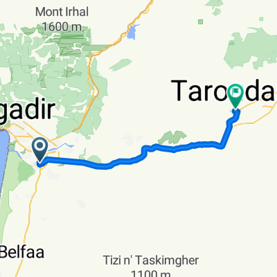
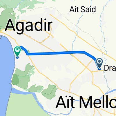
grove route Marokko 2010 -2011- Distance
- 664.1 km
- Ascent
- 3,353 m
- Descent
- 3,392 m
- Location
- Inezgane, Région de Souss-Massa-Drâa, Morocco
Itinéraire récupéré- Distance
- 29.7 km
- Ascent
- 146 m
- Descent
- 152 m
- Location
- Inezgane, Région de Souss-Massa-Drâa, Morocco
Open it in the app


