

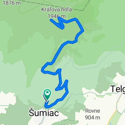
Puste Pole - Kralova hola - Helpa
A cycling route starting in Dobšiná, Košice Region, Slovakia.
Overview
About this route
- -:--
- Duration
- 43.9 km
- Distance
- 1,191 m
- Ascent
- 1,494 m
- Descent
- ---
- Avg. speed
- ---
- Max. altitude
Route highlights
Points of interest along the route

Point of interest after 0.9 km

Point of interest after 12.2 km

Point of interest after 12.2 km

Point of interest after 12.5 km

Point of interest after 12.6 km

Point of interest after 12.6 km

Point of interest after 12.6 km

Point of interest after 14.5 km

Point of interest after 14.6 km

Point of interest after 15 km

Point of interest after 15 km

Point of interest after 16.9 km

Point of interest after 16.9 km

Point of interest after 16.9 km

Point of interest after 17.8 km

Point of interest after 17.8 km

Point of interest after 17.9 km

Point of interest after 18.3 km

Point of interest after 18.4 km

Point of interest after 18.6 km

Point of interest after 19.6 km

Point of interest after 19.6 km

Point of interest after 19.7 km

Point of interest after 20.1 km

Point of interest after 20.1 km

Point of interest after 20.4 km

Point of interest after 20.5 km

Point of interest after 22.8 km

Point of interest after 22.9 km

Point of interest after 23.2 km

Point of interest after 24.1 km

Point of interest after 24.2 km

Point of interest after 24.9 km

Point of interest after 25 km

Point of interest after 25 km

Point of interest after 25.4 km

Point of interest after 25.7 km

Point of interest after 25.7 km

Point of interest after 26.8 km

Point of interest after 26.8 km

Point of interest after 26.9 km

Point of interest after 26.9 km

Point of interest after 36 km

Point of interest after 36.1 km

Point of interest after 36.1 km
Continue with Bikemap
Use, edit, or download this cycling route
You would like to ride Puste Pole - Kralova hola - Helpa or customize it for your own trip? Here is what you can do with this Bikemap route:
Free features
- Save this route as favorite or in collections
- Copy & plan your own version of this route
- Sync your route with Garmin or Wahoo
Premium features
Free trial for 3 days, or one-time payment. More about Bikemap Premium.
- Navigate this route on iOS & Android
- Export a GPX / KML file of this route
- Create your custom printout (try it for free)
- Download this route for offline navigation
Discover more Premium features.
Get Bikemap PremiumFrom our community
Other popular routes starting in Dobšiná
 SK/Telgárt - PL/Zakopane
- Distance
- 98.8 km
- Ascent
- 1,877 m
- Descent
- 1,820 m
- Location
- Dobšiná, Košice Region, Slovakia
 Telgart- Dobšiná- Dobš. ľad jask- Telgárt
- Distance
- 51.8 km
- Ascent
- 1,029 m
- Descent
- 1,039 m
- Location
- Dobšiná, Košice Region, Slovakia
 Telgárt, Telgárt až Telgárt, Telgárt
- Distance
- 48.5 km
- Ascent
- 1,792 m
- Descent
- 1,791 m
- Location
- Dobšiná, Košice Region, Slovakia
 Telgárt, Telgárt až Muráň
- Distance
- 21.6 km
- Ascent
- 667 m
- Descent
- 694 m
- Location
- Dobšiná, Košice Region, Slovakia
 Telgárt - Mlynky - Nálepkovo - Gelnica - Margecany - Košice
- Distance
- 139.9 km
- Ascent
- 2,169 m
- Descent
- 2,837 m
- Location
- Dobšiná, Košice Region, Slovakia
 Kráľova Hoľa
- Distance
- 23.8 km
- Ascent
- 1,024 m
- Descent
- 1,009 m
- Location
- Dobšiná, Košice Region, Slovakia
 Dedinky - Stratená - Stratenský kaňon - Dobšinská Maša - Dedinky CLONED FROM ROUTE 582102
- Distance
- 14.3 km
- Ascent
- 449 m
- Descent
- 445 m
- Location
- Dobšiná, Košice Region, Slovakia
 MTB MARATON MLYNKY 2012
- Distance
- 61.5 km
- Ascent
- 0 m
- Descent
- 0 m
- Location
- Dobšiná, Košice Region, Slovakia
Open it in the app