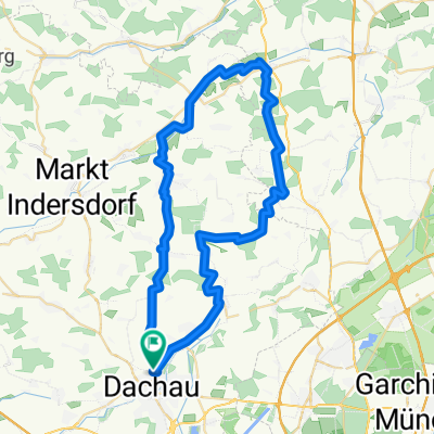
Hohenkammerrunde
A cycling route starting in Dachau, Bavaria, Germany.
Overview
About this route
Nice hinterland loop with about 500 meters of elevation. Places to stop for refreshments at Schloss Hohenkammer and Mariabrunn. The right path to Waltenhofen in the forest is not easy to find... To Waltenhofen, follow the gravel path to the left into the forest; here the path forks and you take the right downhill. The path ends at a cornfield, then ascend about 200 meters; here you return to a gravel path and shortly after arrive in Weißling.
- -:--
- Duration
- 53.2 km
- Distance
- 305 m
- Ascent
- 308 m
- Descent
- ---
- Avg. speed
- ---
- Max. altitude
Continue with Bikemap
Use, edit, or download this cycling route
You would like to ride Hohenkammerrunde or customize it for your own trip? Here is what you can do with this Bikemap route:
Free features
- Save this route as favorite or in collections
- Copy & plan your own version of this route
- Sync your route with Garmin or Wahoo
Premium features
Free trial for 3 days, or one-time payment. More about Bikemap Premium.
- Navigate this route on iOS & Android
- Export a GPX / KML file of this route
- Create your custom printout (try it for free)
- Download this route for offline navigation
Discover more Premium features.
Get Bikemap PremiumFrom our community
Other popular routes starting in Dachau
 Via Claudia Augusta ab München
- Distance
- 376 km
- Ascent
- 5,520 m
- Descent
- 5,716 m
- Location
- Dachau, Bavaria, Germany
 Hinterlandrunde CLONED FROM ROUTE 792316
- Distance
- 58.3 km
- Ascent
- 285 m
- Descent
- 285 m
- Location
- Dachau, Bavaria, Germany
 Dachau nach Markt Indersdorf
- Distance
- 19.7 km
- Ascent
- 1,108 m
- Descent
- 1,124 m
- Location
- Dachau, Bavaria, Germany
 Hohenkammerrunde
- Distance
- 53.2 km
- Ascent
- 305 m
- Descent
- 308 m
- Location
- Dachau, Bavaria, Germany
 Ringstraße 6, Dachau nach Rosenstraße 3–7, Dachau
- Distance
- 48.1 km
- Ascent
- 1,412 m
- Descent
- 1,412 m
- Location
- Dachau, Bavaria, Germany
 Dachauer RTF 2008 CLONED FROM ROUTE 35479
- Distance
- 112.5 km
- Ascent
- 305 m
- Descent
- 309 m
- Location
- Dachau, Bavaria, Germany
 Morgenrunde
- Distance
- 104.7 km
- Ascent
- 740 m
- Descent
- 727 m
- Location
- Dachau, Bavaria, Germany
 Gröbmühlstraße, Dachau nach Oberschleißheim, Oberschleißheim
- Distance
- 9.9 km
- Ascent
- 9 m
- Descent
- 10 m
- Location
- Dachau, Bavaria, Germany
Open it in the app

