

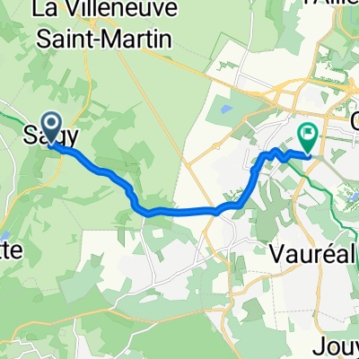
Recovered Route
A cycling route starting in Sagy, Île-de-France Region, France.
Overview
About this route
- 38 min
- Duration
- 9.7 km
- Distance
- 23 m
- Ascent
- 70 m
- Descent
- 15.2 km/h
- Avg. speed
- ---
- Max. altitude

Route quality
Waytypes & surfaces along the route
Waytypes
Path
3.2 km
(33 %)
Track
2.1 km
(22 %)
Surfaces
Paved
6.3 km
(65 %)
Asphalt
5.7 km
(59 %)
Paved (undefined)
0.6 km
(6 %)
Undefined
3.4 km
(35 %)
Continue with Bikemap
Use, edit, or download this cycling route
You would like to ride Recovered Route or customize it for your own trip? Here is what you can do with this Bikemap route:
Free features
- Save this route as favorite or in collections
- Copy & plan your own version of this route
- Sync your route with Garmin or Wahoo
Premium features
Free trial for 3 days, or one-time payment. More about Bikemap Premium.
- Navigate this route on iOS & Android
- Export a GPX / KML file of this route
- Create your custom printout (try it for free)
- Download this route for offline navigation
Discover more Premium features.
Get Bikemap PremiumFrom our community
Other popular routes starting in Sagy
 Recovered Route
- Distance
- 9.7 km
- Ascent
- 23 m
- Descent
- 70 m
- Location
- Sagy, Île-de-France Region, France
 Sagy - Le Perchay - Montgeroult (23km)
- Distance
- 23.3 km
- Ascent
- 231 m
- Descent
- 229 m
- Location
- Sagy, Île-de-France Region, France
 Itinéraire vers 2 Rue du Lendemain, Cergy
- Distance
- 10.3 km
- Ascent
- 95 m
- Descent
- 31 m
- Location
- Sagy, Île-de-France Region, France
 Chemin de la Chaussée Brunehaut, Condécourt à 1 Rue des Aulnes, Condécourt
- Distance
- 8.5 km
- Ascent
- 97 m
- Descent
- 135 m
- Location
- Sagy, Île-de-France Region, France
 De 31N Rue de la Libération, Condécourt à 25 Rue de la Tournade, Herblay
- Distance
- 22.1 km
- Ascent
- 208 m
- Descent
- 181 m
- Location
- Sagy, Île-de-France Region, France
 Chemin des Étangs, Sagy to 2 bis Rue de Fleury, Courdimanche
- Distance
- 5 km
- Ascent
- 155 m
- Descent
- 60 m
- Location
- Sagy, Île-de-France Region, France
 GR1 Sagy -> Melun
- Distance
- 243.5 km
- Ascent
- 2,732 m
- Descent
- 2,738 m
- Location
- Sagy, Île-de-France Region, France
 Rue de la Mairie, Sagy to Avenue du Terroir, Cergy
- Distance
- 6.8 km
- Ascent
- 89 m
- Descent
- 27 m
- Location
- Sagy, Île-de-France Region, France
Open it in the app