

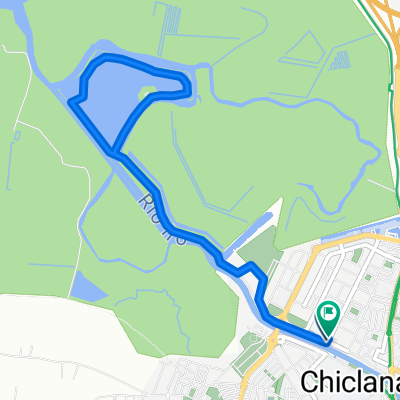
Salina Santa Maria de Jesús
A cycling route starting in Chiclana de la Frontera, Andalusia, Spain.
Overview
About this route
Bici NO PRO
Dificultad: Muy fácil.
Primeros pedaleos de los miembros del blog Bici NO PRO, un paseo suave y tranquilo para empezar a coger forma.
Más fotos y descripción de la ruta en:
Primeros pedaleos, Bici NO PRO
Salina Santa Maria de Jesús, Bici NO PRO
Atención: La ruta está dibujada sobre el mapa, no con GPS. El trazado es de ida y vuelta.<br />
- -:--
- Duration
- 7.1 km
- Distance
- 24 m
- Ascent
- 24 m
- Descent
- ---
- Avg. speed
- ---
- Max. altitude

Route quality
Waytypes & surfaces along the route
Waytypes
Track
2.5 km
(36 %)
Quiet road
2 km
(29 %)
Surfaces
Paved
1.3 km
(18 %)
Unpaved
4.4 km
(61 %)
Unpaved (undefined)
4.1 km
(58 %)
Asphalt
1.3 km
(18 %)
Route highlights
Points of interest along the route

Point of interest after 3.5 km

Point of interest after 4.2 km

Point of interest after 4.3 km

Point of interest after 4.5 km

Point of interest after 5.6 km

Point of interest after 6.5 km
Continue with Bikemap
Use, edit, or download this cycling route
You would like to ride Salina Santa Maria de Jesús or customize it for your own trip? Here is what you can do with this Bikemap route:
Free features
- Save this route as favorite or in collections
- Copy & plan your own version of this route
- Sync your route with Garmin or Wahoo
Premium features
Free trial for 3 days, or one-time payment. More about Bikemap Premium.
- Navigate this route on iOS & Android
- Export a GPX / KML file of this route
- Create your custom printout (try it for free)
- Download this route for offline navigation
Discover more Premium features.
Get Bikemap PremiumFrom our community
Other popular routes starting in Chiclana de la Frontera
 Salina Santa Maria de Jesús
- Distance
- 7.1 km
- Ascent
- 24 m
- Descent
- 24 m
- Location
- Chiclana de la Frontera, Andalusia, Spain
 E_NSP-Barbate-LosNaveros-NSP
- Distance
- 118.7 km
- Ascent
- 660 m
- Descent
- 657 m
- Location
- Chiclana de la Frontera, Andalusia, Spain
 Carrera Chiclana
- Distance
- 103.6 km
- Ascent
- 661 m
- Descent
- 653 m
- Location
- Chiclana de la Frontera, Andalusia, Spain
 QCALOR
- Distance
- 16.9 km
- Ascent
- 32 m
- Descent
- 58 m
- Location
- Chiclana de la Frontera, Andalusia, Spain
 Naveros
- Distance
- 33.8 km
- Ascent
- 365 m
- Descent
- 362 m
- Location
- Chiclana de la Frontera, Andalusia, Spain
 campano - los naveros - medina - chiclana
- Distance
- 59.8 km
- Ascent
- 435 m
- Descent
- 435 m
- Location
- Chiclana de la Frontera, Andalusia, Spain
 RELAX
RELAX- Distance
- 30.2 km
- Ascent
- 67 m
- Descent
- 33 m
- Location
- Chiclana de la Frontera, Andalusia, Spain
 Medina ---Los Naveros--Barrio Nuevo--HBH-68 km
- Distance
- 68.4 km
- Ascent
- 486 m
- Descent
- 487 m
- Location
- Chiclana de la Frontera, Andalusia, Spain
Open it in the app