Bad Staffelstein-Eltmann
A cycling route starting in Bad Staffelstein, Bavaria, Germany.
Overview
About this route
- -:--
- Duration
- 49.9 km
- Distance
- 185 m
- Ascent
- 205 m
- Descent
- ---
- Avg. speed
- 264 m
- Avg. speed
Route quality
Waytypes & surfaces along the route
Waytypes
Quiet road
14.5 km
(29 %)
Track
10.8 km
(22 %)
Surfaces
Paved
44.3 km
(89 %)
Unpaved
2.9 km
(6 %)
Asphalt
41 km
(82 %)
Concrete
2.7 km
(5 %)
Route highlights
Points of interest along the route
Point of interest after 25.2 km
Bier
Continue with Bikemap
Use, edit, or download this cycling route
You would like to ride Bad Staffelstein-Eltmann or customize it for your own trip? Here is what you can do with this Bikemap route:
Free features
- Save this route as favorite or in collections
- Copy & plan your own version of this route
- Sync your route with Garmin or Wahoo
Premium features
Free trial for 3 days, or one-time payment. More about Bikemap Premium.
- Navigate this route on iOS & Android
- Export a GPX / KML file of this route
- Create your custom printout (try it for free)
- Download this route for offline navigation
Discover more Premium features.
Get Bikemap PremiumFrom our community
Other popular routes starting in Bad Staffelstein
- MTB-Rund um Bad Staffelstein
- Distance
- 29.4 km
- Ascent
- 603 m
- Descent
- 598 m
- Location
- Bad Staffelstein, Bavaria, Germany
- Zur Hohen Metze und zur Giechburg
- Distance
- 47 km
- Ascent
- 708 m
- Descent
- 692 m
- Location
- Bad Staffelstein, Bavaria, Germany
- BAD STAFFELSTEIN 1
- Distance
- 43.2 km
- Ascent
- 380 m
- Descent
- 380 m
- Location
- Bad Staffelstein, Bavaria, Germany
- Bad St´stein-14´hlg.-Hasenweg-Karlsbank
- Distance
- 26.6 km
- Ascent
- 526 m
- Descent
- 526 m
- Location
- Bad Staffelstein, Bavaria, Germany
- Bad Staffelstein Bamberg und zurück
- Distance
- 62.6 km
- Ascent
- 139 m
- Descent
- 126 m
- Location
- Bad Staffelstein, Bavaria, Germany
- 27.08.18_Schönbrunn nach Eltmann
- Distance
- 65.4 km
- Ascent
- 76 m
- Descent
- 99 m
- Location
- Bad Staffelstein, Bavaria, Germany
- ADFC Tour 18.07.2010
- Distance
- 66.7 km
- Ascent
- 411 m
- Descent
- 413 m
- Location
- Bad Staffelstein, Bavaria, Germany
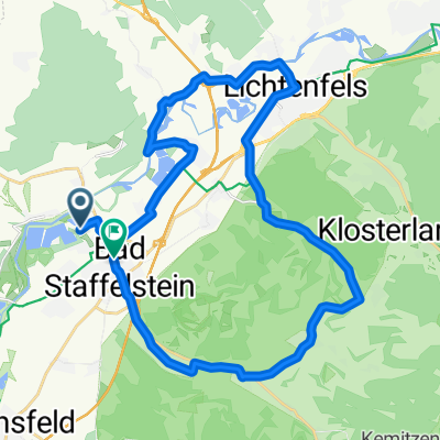
- Rund um den Staffelberg mit Abstecher nach Vierzehnheiligen
- Distance
- 34.7 km
- Ascent
- 677 m
- Descent
- 677 m
- Location
- Bad Staffelstein, Bavaria, Germany